1900s (20th Century) Maps of Jakes Colony, Texas
Explore 7 historic maps of Jakes Colony from the 1900s (20th Century). These maps offer a rare glimpse into what life looked like during the 1900s — showing old roads, neighborhoods, homes, and landmarks that have changed or disappeared over time.
Whether you're researching your family's past, planning a metal detecting trip, or studying how Jakes Colony's landscape evolved across the 1900s, these high-resolution maps are a powerful tool for exploring the history of this region.
- Focus on a specific era: All maps on this page are from the 1900s, giving you a focused view of this time period.
- See what’s changed: Compare century-old streets, trails, and buildings to today's modern landscape using overlays and satellite layers.
- Research with precision: Use these maps for genealogy, historical research, land use analysis, or educational projects.
- View, download, or print: Maps are fully viewable online in high resolution, and can be downloaded or printed for your own records.
Start exploring Jakes Colony's history through authentic maps from the 1900s. This is your window into the past.
Jakes Colony, TX maps
(7)- 1920 Map of Smiley
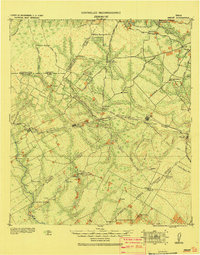 1920 Smiley1920 Print · USGSSouth Texas ranching and rail life are preserved here in the era following the first World War. Genealogists can trace family roots through labeled landmarks like Willow Springs Ranch, the Southern Pacific Railroad, and the settlement at Nixon.
 - 1942 Map of Dewville
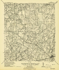 1942 Dewville1942 Print · USGSThe rural borderlands of South Texas are mapped here just before the mid-century, showing a landscape of family ranches and crossroads stores. Researchers can locate ancestral sites like Thomas Springs Ranch and long-standing community centers such as Bethel School and Zion Hill Church.
 - 1953 Map of Seguin, 1965 Print
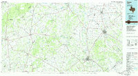
 1953 Seguin1965 Print · USGSSouth Texas in the early fifties shows a thriving river-and-rail economy across the Guadalupe and Colorado basins. Genealogists and historians can trace rail routes like the Southern Pacific through Seguin, locate oil wells, or find the Gary AAF near San Marcos.4 unique versions available
 - 1956 Map of Dewville
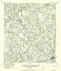 1956 Dewville1956 Print · USGSGuadalupe and Wilson counties are captured here in the mid-1930s, showing a landscape defined by cattle ranching and rural schools. Genealogists can trace family homesteads like Joe Cliff Ranch and Ballard and Place Ranch or find ancestral sites at Zion Hill Church.
 - 1958 Map of Seguin
 1958 Seguin1958 Print · USGSSouth Texas in the late fifties was a network of river-valley settlements and active oilfields tied together by major rail lines. Genealogists and historians can trace family-named sites across Rabb Prairie, locate the Behring Store, or follow the Southern Pacific through Schulenburg.
 - 1961 Map of Thomas Springs, 1963 Print
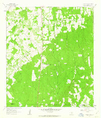 1961 Thomas Springs1963 Print · USGSThe Guadalupe and Wilson county line comes alive in the early sixties, showing a landscape of dispersed ranches and creek-side communities. Genealogists can trace family footprints at Zion Hill Cem, Weinert Ranch, and Jakes Colony Ch.3 unique versions available
 - 1985 Map of Cuero
 1985 Cuero1985 Print · USGSSouth Texas in the mid-eighties reveals a landscape of river-bottom farms and active petroleum production. Researchers can trace family-named landmarks and rural settlements like Monthalia, Kosciuszko, and the Thomaston Oil Field along the Southern Pacific rail lines.2 unique versions available
End of results
Showing maps 1-7 of 7
Top cities near Jakes Colony
- New Braunfels historical maps
- Schertz historical maps
- Seguin historical maps
- Cibolo historical maps
- Nixon historical maps
- Saint Hedwig historical maps
See more
Frequently asked questions
- What are the different types of historical maps available for Jakes Colony?
- What is the oldest map of Jakes Colony?
- Where can I purchase historical maps of Jakes Colony for my home or office?
- Where can I download high-res historical maps of Jakes Colony?
- Are there historical topographic maps available for Jakes Colony?
- Is there historical aerial imagery available for Jakes Colony?
- Where are historical maps of Jakes Colony sourced from?