1990s Maps of Hardeman County, Texas
Explore 9 historic maps of Hardeman County from the 1990s. These maps offer a rare glimpse into what life looked like during the 1990s — showing old roads, neighborhoods, homes, and landmarks that have changed or disappeared over time.
Whether you're researching your family's past, planning a metal detecting trip, or studying how Hardeman County's landscape evolved across the 1990s, these high-resolution maps are a powerful tool for exploring the history of this region.
- Focus on a specific era: All maps on this page are from the 1990s, giving you a focused view of this time period.
- See what’s changed: Compare century-old streets, trails, and buildings to today's modern landscape using overlays and satellite layers.
- Research with precision: Use these maps for genealogy, historical research, land use analysis, or educational projects.
- View, download, or print: Maps are fully viewable online in high resolution, and can be downloaded or printed for your own records.
Start exploring Hardeman County's history through authentic maps from the 1990s. This is your window into the past.
Hardeman County, TX maps
(9)- 1990 Map of Cactus Creek, 1995 Print
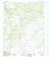
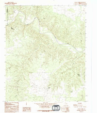 1990 Cactus Creek1995 Print · USGSThe Foard and Hardeman County line in the 1990s was a landscape of deep canyons and seasonal water sources. Local history researchers can trace the winding Pease River and locate vital landmarks like Dripping Springs and Red Bluff.
 - 1990 Map of Maybell Canyon, 1995 Print
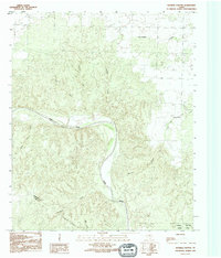 1990 Maybell Canyon1995 Print · USGSHardeman and Foard counties are captured here in the early nineties, centered on the deep breaks of the Pease River valley. Topography buffs and researchers can trace the drainages of Maybell Canyon and Wanderers Creek or locate the boundaries of Copper Breaks State Park.
 - 1990 Map of Quanah West, 1995 Print
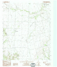
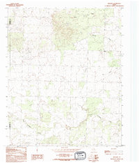
 1990 Quanah West1995 Print · USGSHardeman County's ranching and industrial landscape is captured here in the 1990s as the regional economy centered around Quanah. Researchers can trace the path of Groesbeck Creek through small outposts like Acme and Talbert Crossing.
 - 1990 Map of Medicine Mound, 1995 Print
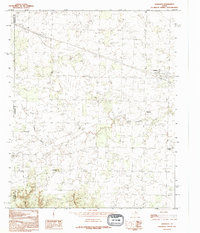
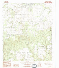
 1990 Medicine Mound1995 Print · USGSHardeman County in the early nineties shows a landscape of traditional ranching punctuated by modern utility infrastructure. Trace the notable peaks of Medicine Mounds and Cedar Mound, or locate the rural Cem and the settlement at Chillicothe.
 - 1990 Map of Goodlett, 1995 Print
 1990 Goodlett1995 Print · USGSThe intersection of Childress, Hardeman, and Cottle counties in North Texas is captured here during the 1990s. Researchers can trace rural settlement patterns through communities like Goodlett and Wheatland or find landmarks such as Hepsidam Hill and Punkin Center.
 - 1990 Map of Margaret, 1995 Print
 1990 Margaret1995 Print · USGSThe rural landscape of Foard County in the 1990s is captured here, centered on the settlement of Margaret. Researchers can trace the watercourses and landmarks of this ranching country, from Raggedy Mountain to the canyons of Copper Breaks State Park.
 - 1990 Map of Big Mound, 1995 Print
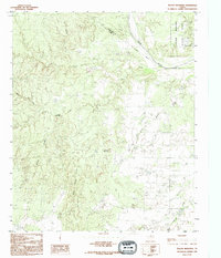
 1990 Big Mound1995 Print · USGSHardeman County, Texas, is defined by its distinct landforms and creek networks in the late twentieth century. Trace the topography surrounding the iconic Medicine Mounds or locate the boundaries of Copper Breaks State Park and Lake Pauline.
 - 1990 Map of Willams, 1995 Print
 1990 Willams1995 Print · USGSHardeman and Childress counties remained a quiet ranching landscape in the late twentieth century, largely unchanged from decades prior. Local researchers can trace the course of North Groesbeck Creek and find the small community of Williams.
 - 1990 Map of Teacup Mountain, 1995 Print
 1990 Teacup Mountain1995 Print · USGSThe North Texas borderlands come alive in the 1990s as the Pease River carves through the canyon country. Trace the geography of the parklands at Copper Breaks State Park or locate landmarks like Teacup Mountain and Sloans Springs.
End of results
Showing maps 1-9 of 9
Top cities of Hardeman County
Frequently asked questions
- What are the different types of historical maps available for Hardeman County?
- What is the oldest map of Hardeman County?
- Where can I purchase historical maps of Hardeman County for my home or office?
- Where can I download high-res historical maps of Hardeman County?
- Are there historical topographic maps available for Hardeman County?
- Is there historical aerial imagery available for Hardeman County?
- Where are historical maps of Hardeman County sourced from?