1980s Maps of Quanah, Texas
Explore 3 historic maps of Quanah from the 1980s. These maps offer a rare glimpse into what life looked like during the 1980s — showing old roads, neighborhoods, homes, and landmarks that have changed or disappeared over time.
Whether you're researching your family's past, planning a metal detecting trip, or studying how Quanah's landscape evolved across the 1980s, these high-resolution maps are a powerful tool for exploring the history of this region.
- Focus on a specific era: All maps on this page are from the 1980s, giving you a focused view of this time period.
- See what’s changed: Compare century-old streets, trails, and buildings to today's modern landscape using overlays and satellite layers.
- Research with precision: Use these maps for genealogy, historical research, land use analysis, or educational projects.
- View, download, or print: Maps are fully viewable online in high resolution, and can be downloaded or printed for your own records.
Start exploring Quanah's history through authentic maps from the 1980s. This is your window into the past.
Quanah, TX maps
(3)- 1984 Map of Quanah West, 1985 Print
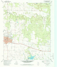
 1984 Quanah West1985 Print · USGSHardeman County, Texas, was defined by its railroad arteries and creek drainage systems in the 1980s. Genealogists and local historians can trace the paths of the Burlington Northern Railroad, the settlement at Acme, and the legacy of the Old RR Grade.
 - 1984 Map of Quanah East, 1985 Print
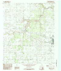
 1984 Quanah East1985 Print · USGSQuanah and the surrounding Hardeman County plains are captured in the mid-1980s, showcasing a landscape of rail transit and oil production. Genealogists and historians can locate Quanah, the Conley Oil Field, and Memorial Park (Cem) near the Red River border.
 - 1986 Map of Vernon
 1986 Vernon1986 Print · USGSNorth Texas and Southern Oklahoma meet along the river in the mid-1980s, revealing a landscape defined by ranching, oil production, and rail transport. Researchers can locate distinct landmarks such as Medicine Mound, the Conley Oil Field, and the community of Punkin Center.
End of results
Showing maps 1-3 of 3
Top cities near Quanah
Frequently asked questions
- What are the different types of historical maps available for Quanah?
- What is the oldest map of Quanah?
- Where can I purchase historical maps of Quanah for my home or office?
- Where can I download high-res historical maps of Quanah?
- Are there historical topographic maps available for Quanah?
- Is there historical aerial imagery available for Quanah?
- Where are historical maps of Quanah sourced from?