1910s Maps of Humble, Texas
Explore 5 historic maps of Humble from the 1910s. These maps offer a rare glimpse into what life looked like during the 1910s — showing old roads, neighborhoods, homes, and landmarks that have changed or disappeared over time.
Whether you're researching your family's past, planning a metal detecting trip, or studying how Humble's landscape evolved across the 1910s, these high-resolution maps are a powerful tool for exploring the history of this region.
- Focus on a specific era: All maps on this page are from the 1910s, giving you a focused view of this time period.
- See what’s changed: Compare century-old streets, trails, and buildings to today's modern landscape using overlays and satellite layers.
- Research with precision: Use these maps for genealogy, historical research, land use analysis, or educational projects.
- View, download, or print: Maps are fully viewable online in high resolution, and can be downloaded or printed for your own records.
Start exploring Humble's history through authentic maps from the 1910s. This is your window into the past.
Humble, TX maps
(5)- 1916 Map of Harmaston
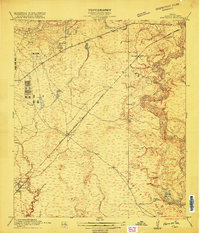 1916 Harmaston1916 Print · USGSCoastal Harris County was a network of railroad stops and bayous during the early twentieth century. Trace the early settlement patterns of Harmaston and Victor along the Beaumont Sour Lake and Western tracks near Ingram Marsh.2 unique versions available
 - 1916 Map of Moonshine Hill
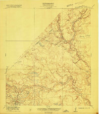 1916 Moonshine Hill1916 Print · USGSHarris and Montgomery counties appear here in the early twentieth century as a complex landscape of river forks and wetlands. Genealogists and historians can trace old property lines and natural landmarks like Odom Lake Swamp, Bosman Lake, and the H. E. and W. T. rail line.3 unique versions available
 - 1916 Map of Humble
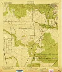
 1916 Humble1916 Print · USGSHarris County is captured here in the early twentieth century as small rail-side settlements began to dot the coastal prairie. Local historians can trace the foundations of Humble and Mt Houston or locate the rural Higgs School and a small Cem near the winding Greens Bayou.2 unique versions available
 - 1919 Map of Humble
 1919 Humble1919 Print · USGSHarris County at the height of the early oil era is defined by the convergence of major rail lines and bayou-side settlements. Genealogists and industrial historians can trace the early footprints of Humble, the location of Higgs School, and the dense rail network of the International and Great Northern.3 unique versions available
 - 1919 Map of Weeden
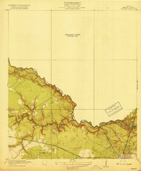 1919 Weeden1919 Print · USGSSoutheast Texas at the end of the Great War was a landscape of creek-fed bottomlands and emerging rail hubs. Trace the early layout of Humble and locate family landmarks like the Tullus Cemetery or the route of the Bender Tramroad.2 unique versions available
End of results
Showing maps 1-5 of 5
Top cities near Humble
- Houston historical maps
- The Woodlands historical maps
- Conroe historical maps
- Atascocita historical maps
- Kingwood historical maps
- Baytown historical maps
See more
Top neighborhoods of Humble
Frequently asked questions
- What are the different types of historical maps available for Humble?
- What is the oldest map of Humble?
- Where can I purchase historical maps of Humble for my home or office?
- Where can I download high-res historical maps of Humble?
- Are there historical topographic maps available for Humble?
- Is there historical aerial imagery available for Humble?
- Where are historical maps of Humble sourced from?