1960s Maps of Pasadena, Texas
Explore 2 historic maps of Pasadena from the 1960s. These maps offer a rare glimpse into what life looked like during the 1960s — showing old roads, neighborhoods, homes, and landmarks that have changed or disappeared over time.
Whether you're researching your family's past, planning a metal detecting trip, or studying how Pasadena's landscape evolved across the 1960s, these high-resolution maps are a powerful tool for exploring the history of this region.
- Focus on a specific era: All maps on this page are from the 1960s, giving you a focused view of this time period.
- See what’s changed: Compare century-old streets, trails, and buildings to today's modern landscape using overlays and satellite layers.
- Research with precision: Use these maps for genealogy, historical research, land use analysis, or educational projects.
- View, download, or print: Maps are fully viewable online in high resolution, and can be downloaded or printed for your own records.
Start exploring Pasadena's history through authentic maps from the 1960s. This is your window into the past.
Pasadena, TX maps
(2)- 1967 Map of Pasadena, 1970 Print
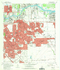 1967 Pasadena1970 Print · USGSSoutheast of Houston in the late sixties, this area shows a dense industrial and suburban landscape emerging along the Houston Ship Channel. Genealogists and local historians can locate established schools like Pearl Hall Sch and landmarks like the Texas Chiropractic College or the crossroads at Genoa.
 - 1967 Map of La Porte, 1970 Print
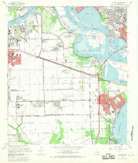 1967 La Porte1970 Print · USGSCoastal Harris County in the late sixties shows a landscape where industrial shipping channels meet growing bayfront communities. Genealogists and local historians can trace residential patterns in Lomax, locate Betheny Cem, and see the early footprint of San Jacinto College.
End of results
Showing maps 1-2 of 2
Top cities near Pasadena
- Houston historical maps
- Pearland historical maps
- League City historical maps
- Baytown historical maps
- Channelview historical maps
- Texas City historical maps
See more
Top neighborhoods of Pasadena
- Golden Acres historical maps
- El Jardin Del Mar historical maps
- Country Briar historical maps
- Deer Creek historical maps
- Firwood Village historical maps
- Parkview South historical maps
See more
Frequently asked questions
- What are the different types of historical maps available for Pasadena?
- What is the oldest map of Pasadena?
- Where can I purchase historical maps of Pasadena for my home or office?
- Where can I download high-res historical maps of Pasadena?
- Are there historical topographic maps available for Pasadena?
- Is there historical aerial imagery available for Pasadena?
- Where are historical maps of Pasadena sourced from?