1980s Maps of Pasadena, Texas
Explore 5 historic maps of Pasadena from the 1980s. These maps offer a rare glimpse into what life looked like during the 1980s — showing old roads, neighborhoods, homes, and landmarks that have changed or disappeared over time.
Whether you're researching your family's past, planning a metal detecting trip, or studying how Pasadena's landscape evolved across the 1980s, these high-resolution maps are a powerful tool for exploring the history of this region.
- Focus on a specific era: All maps on this page are from the 1980s, giving you a focused view of this time period.
- See what’s changed: Compare century-old streets, trails, and buildings to today's modern landscape using overlays and satellite layers.
- Research with precision: Use these maps for genealogy, historical research, land use analysis, or educational projects.
- View, download, or print: Maps are fully viewable online in high resolution, and can be downloaded or printed for your own records.
Start exploring Pasadena's history through authentic maps from the 1980s. This is your window into the past.
Pasadena, TX maps
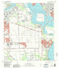
(5)- 1982 Map of League City
 1982 League City1982 Print · USGSThe coastal corridor south of Houston was a hub of aerospace innovation and maritime industry in the early eighties. Researchers can locate the NASA Space Center, the Houston Gulf Airport, and local landmarks like Fairview Cem or the Southern Pacific tracks.3 unique versions available
 - 1982 Map of Bacliff
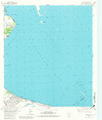 1982 Bacliff1982 Print · USGSUpper Galveston Bay and the Texas coast come alive in this early eighties survey of the bustling Houston maritime corridor. Genealogists and local historians can trace the development of Bacliff, San Leon, and Seabrook alongside the heavy industrial footprint of the Oil Field.
 - 1982 Map of La Porte, 1983 Print
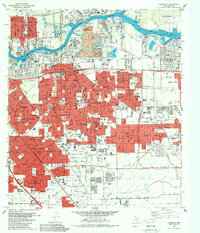
 1982 La Porte1983 Print · USGSThe industrial and maritime heart of the Texas coast comes into focus in the early eighties as the ship channel drives the local economy. Trace family history and regional growth at La Porte, San Jacinto State Park, and the Wooster Cem.
 - 1982 Map of Pasadena, 1983 Print
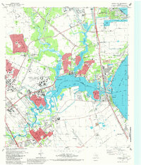
 1982 Pasadena1983 Print · USGSGreater Houston experienced significant industrial and suburban maturation by the early eighties, centered on the vital shipping corridors. Researchers can trace family roots through neighborhood landmarks like Crown Hill Cem or locate former aviation sites such as Genoa Airport.
 - 1983 Map of Anahuac
 1983 Anahuac1983 Print · USGSThe Upper Texas Coast and its energy-driven landscape are detailed here in the early eighties. Genealogists and historians can trace coastal settlements like Anahuac and Winnie alongside the storied Spindletop Oil Field and the Anahuac National Wildlife Refuge.2 unique versions available
End of results
Showing maps 1-5 of 5
Top cities near Pasadena
- Houston historical maps
- Pearland historical maps
- League City historical maps
- Baytown historical maps
- Channelview historical maps
- Texas City historical maps
See more
Top neighborhoods of Pasadena
- Golden Acres historical maps
- El Jardin Del Mar historical maps
- Country Briar historical maps
- Deer Creek historical maps
- Firwood Village historical maps
- Parkview South historical maps
See more
Frequently asked questions
- What are the different types of historical maps available for Pasadena?
- What is the oldest map of Pasadena?
- Where can I purchase historical maps of Pasadena for my home or office?
- Where can I download high-res historical maps of Pasadena?
- Are there historical topographic maps available for Pasadena?
- Is there historical aerial imagery available for Pasadena?
- Where are historical maps of Pasadena sourced from?