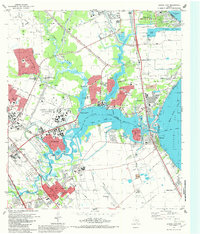
1982 Map of League City
USGS Topo · Published 1982About this map
The Lyndon B Johnson Space Center (NASA) dominates the coastal landscape of this 1982 record, signaling the era's deep ties to aerospace and research near Clear Lake. The interface between heavy industry and residential growth is evident through the development of League City and Clear Lake City, alongside the massive infrastructure of the Bayport Ship Channel feeding into Galveston Bay. Academic and scientific presence is further noted by the University of Houston (Clear Lake City Campus) and the Lunar and Planetary Institute (Rice University).
Find a feature on this map
86 named features on this map. Tap any name to fly to it.
Don’t see what you’re looking for? This feature index may not catch every label — zoom into the map to look around manually.
Map Details
Editions of this 1982 League City Map
3 editions found
Other maps of this area

1915 · Deepwater
USGS Topo · 1:24,000

1916 · Genoa
USGS Topo · 1:24,000

1916 · Morgan Point
USGS Topo · 1:24,000

1916 · Seabrook
USGS Topo · 1:24,000

1916 · La Porte
USGS Topo · 1:24,000

1919 · Morgan Point
USGS Topo · 1:31,680

1919 · Deepwater
USGS Topo · 1:31,680

1920 · Seabrook
USGS Topo · 1:31,680

1920 · Genoa
USGS Topo · 1:31,680

1920 · La Porte
USGS Topo · 1:31,680