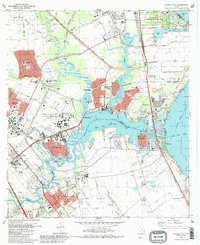
1982 Map of League City
USGS Topo · Published 1986About this map
The Lyndon B Johnson Space Center (NASA) anchors this coastal landscape, reflecting the space-age growth of the early 1980s along the shores of Clear Lake. This era saw the rapid suburban expansion of League City, Nassau Bay, and Taylor Lake Village, where residential developments are interspersed with institutional landmarks like the University of Houston (Clear Lake City Campus) and the Lunar and Planetary Institute.
Find a feature on this map
61 named features on this map. Tap any name to fly to it.
Don’t see what you’re looking for? This feature index may not catch every label — zoom into the map to look around manually.
Map Details
Editions of this 1982 League City Map
3 editions found
Other maps of this area

1915 · Deepwater
USGS Topo · 1:24,000

1916 · Genoa
USGS Topo · 1:24,000

1916 · Morgan Point
USGS Topo · 1:24,000

1916 · Seabrook
USGS Topo · 1:24,000

1916 · La Porte
USGS Topo · 1:24,000

1919 · Morgan Point
USGS Topo · 1:31,680

1919 · Deepwater
USGS Topo · 1:31,680

1920 · Seabrook
USGS Topo · 1:31,680

1920 · Genoa
USGS Topo · 1:31,680

1920 · La Porte
USGS Topo · 1:31,680