1960s Maps of Marshall, Texas
Explore 2 historic maps of Marshall from the 1960s. These maps offer a rare glimpse into what life looked like during the 1960s — showing old roads, neighborhoods, homes, and landmarks that have changed or disappeared over time.
Whether you're researching your family's past, planning a metal detecting trip, or studying how Marshall's landscape evolved across the 1960s, these high-resolution maps are a powerful tool for exploring the history of this region.
- Focus on a specific era: All maps on this page are from the 1960s, giving you a focused view of this time period.
- See what’s changed: Compare century-old streets, trails, and buildings to today's modern landscape using overlays and satellite layers.
- Research with precision: Use these maps for genealogy, historical research, land use analysis, or educational projects.
- View, download, or print: Maps are fully viewable online in high resolution, and can be downloaded or printed for your own records.
Start exploring Marshall's history through authentic maps from the 1960s. This is your window into the past.
Marshall, TX maps
(2)- 1962 Map of Marshall West, 1963 Print
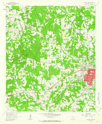 1962 Marshall West1963 Print · USGSHarrison County in the early sixties showcases the expansion of Marshall along the Texas and Pacific rail lines. Researchers can trace historic local landmarks like Wiley College, the Woodlawn Oil Field, and Grover Cem.2 unique versions available
 - 1962 Map of Marshall East, 1964 Print
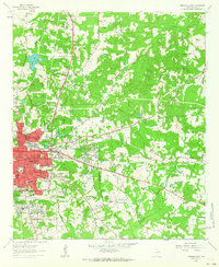 1962 Marshall East1964 Print · USGSHarrison County at the start of the sixties shows a period of rapid growth as residential neighborhoods pushed east from the city center. Trace local lineage and land use through Algeria Cem, the Woodlawn Gas Field, and Pemberton High Sch.2 unique versions available
End of results
Showing maps 1-2 of 2
Top cities near Marshall
- Hallsville historical maps
- Jefferson historical maps
- Scottsville historical maps
- Uncertain historical maps
Top neighborhoods of Marshall
Frequently asked questions
- What are the different types of historical maps available for Marshall?
- What is the oldest map of Marshall?
- Where can I purchase historical maps of Marshall for my home or office?
- Where can I download high-res historical maps of Marshall?
- Are there historical topographic maps available for Marshall?
- Is there historical aerial imagery available for Marshall?
- Where are historical maps of Marshall sourced from?