1960s Maps of San Marcos, Texas
Explore 4 historic maps of San Marcos from the 1960s. These maps offer a rare glimpse into what life looked like during the 1960s — showing old roads, neighborhoods, homes, and landmarks that have changed or disappeared over time.
Whether you're researching your family's past, planning a metal detecting trip, or studying how San Marcos's landscape evolved across the 1960s, these high-resolution maps are a powerful tool for exploring the history of this region.
- Focus on a specific era: All maps on this page are from the 1960s, giving you a focused view of this time period.
- See what’s changed: Compare century-old streets, trails, and buildings to today's modern landscape using overlays and satellite layers.
- Research with precision: Use these maps for genealogy, historical research, land use analysis, or educational projects.
- View, download, or print: Maps are fully viewable online in high resolution, and can be downloaded or printed for your own records.
Start exploring San Marcos's history through authentic maps from the 1960s. This is your window into the past.
San Marcos, TX maps
(4)- 1964 Map of Hunter, 1965 Print
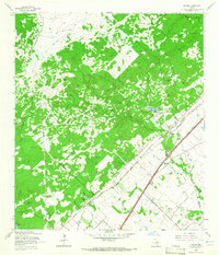 1964 Hunter1965 Print · USGSMid-century Comal County is characterized by a dense network of family cemeteries and dual-rail transit through the settlement of Hunter. Researchers can locate historic rural burial grounds like Rosenthal Cem and trace the paths of the Missouri Pacific and Missouri Kansas Texas lines.5 unique versions available
 - 1964 Map of San Marcos South, 1966 Print
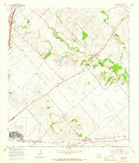
 1964 San Marcos South1966 Print · USGSThe rural hills south of San Marcos were defined by a junction of major railroads and creek-fed farms in the mid-1960s. Researchers can trace family history through sites like Pitts Cemetery or locate old school sites like Bowie School near Centerpoint.3 unique versions available
 - 1964 Map of Uhland, 1966 Print
 1964 Uhland1966 Print · USGSThe Blackland Prairie of Hays and Caldwell Counties comes into focus during the mid-1960s, a time when small agricultural hubs still dominated the landscape. You can trace family roots through localized sites like Doyle Cem, San Juan Ch, and the rail-side community of Maxwell.3 unique versions available
 - 1964 Map of San Marcos North, 1966 Print
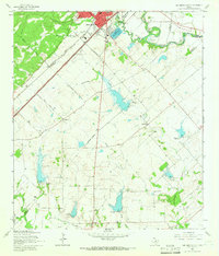
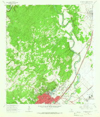 1964 San Marcos North1966 Print · USGSThe hill country transition near San Marcos and Kyle is documented here in the mid-1960s, showing the intersection of river, rail, and university life. Researchers can trace the grounds of Southwest Texas State College or find family sites at Kyle Cem and Guadalupe Cem.5 unique versions available
End of results
Showing maps 1-4 of 4
Top cities near San Marcos
- New Braunfels historical maps
- Seguin historical maps
- Kyle historical maps
- Buda historical maps
- Lockhart historical maps
- Wimberley historical maps
See more
Top neighborhoods of San Marcos
- Centex historical maps
- Blanco Vista historical maps
- East Guadalupe historical maps
- Fairlawn historical maps
- Rio Vista historical maps
- Victory Gardens historical maps
See more
Frequently asked questions
- What are the different types of historical maps available for San Marcos?
- What is the oldest map of San Marcos?
- Where can I purchase historical maps of San Marcos for my home or office?
- Where can I download high-res historical maps of San Marcos?
- Are there historical topographic maps available for San Marcos?
- Is there historical aerial imagery available for San Marcos?
- Where are historical maps of San Marcos sourced from?