1990s Maps of San Marcos, Texas
Explore 2 historic maps of San Marcos from the 1990s. These maps offer a rare glimpse into what life looked like during the 1990s — showing old roads, neighborhoods, homes, and landmarks that have changed or disappeared over time.
Whether you're researching your family's past, planning a metal detecting trip, or studying how San Marcos's landscape evolved across the 1990s, these high-resolution maps are a powerful tool for exploring the history of this region.
- Focus on a specific era: All maps on this page are from the 1990s, giving you a focused view of this time period.
- See what’s changed: Compare century-old streets, trails, and buildings to today's modern landscape using overlays and satellite layers.
- Research with precision: Use these maps for genealogy, historical research, land use analysis, or educational projects.
- View, download, or print: Maps are fully viewable online in high resolution, and can be downloaded or printed for your own records.
Start exploring San Marcos's history through authentic maps from the 1990s. This is your window into the past.
San Marcos, TX maps
(2)- 1992 Map of New Braunfels
 1992 New Braunfels1992 Print · USGSThe San Antonio and New Braunfels corridor was expanding rapidly in the early nineties, balancing heavy military presence with Hill Country recreation. Trace the footprint of CAMP BULLIS MILITARY RESERVATION or locate old railroad stops along the Southern Pacific and Missouri Pacific lines.2 unique versions available
 - 1995 Map of San Marcos North, 1998 Print
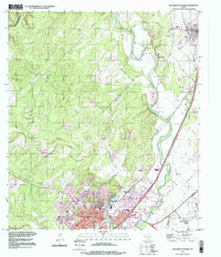 1995 San Marcos North1998 Print · USGSHays County at the end of the twentieth century shows a landscape defined by the growing corridor between San Marcos and Kyle. Trace family history at the San Vincente Cem or explore the riverfront developments near Spring Lake and Fivemile Dam Park.
End of results
Showing maps 1-2 of 2
Top cities near San Marcos
- New Braunfels historical maps
- Seguin historical maps
- Kyle historical maps
- Buda historical maps
- Lockhart historical maps
- Wimberley historical maps
See more
Top neighborhoods of San Marcos
- Centex historical maps
- Blanco Vista historical maps
- East Guadalupe historical maps
- Fairlawn historical maps
- Rio Vista historical maps
- Victory Gardens historical maps
See more
Frequently asked questions
- What are the different types of historical maps available for San Marcos?
- What is the oldest map of San Marcos?
- Where can I purchase historical maps of San Marcos for my home or office?
- Where can I download high-res historical maps of San Marcos?
- Are there historical topographic maps available for San Marcos?
- Is there historical aerial imagery available for San Marcos?
- Where are historical maps of San Marcos sourced from?