1960s Maps of Henderson County, Texas
Explore 9 historic maps of Henderson County from the 1960s. These maps offer a rare glimpse into what life looked like during the 1960s — showing old roads, neighborhoods, homes, and landmarks that have changed or disappeared over time.
Whether you're researching your family's past, planning a metal detecting trip, or studying how Henderson County's landscape evolved across the 1960s, these high-resolution maps are a powerful tool for exploring the history of this region.
- Focus on a specific era: All maps on this page are from the 1960s, giving you a focused view of this time period.
- See what’s changed: Compare century-old streets, trails, and buildings to today's modern landscape using overlays and satellite layers.
- Research with precision: Use these maps for genealogy, historical research, land use analysis, or educational projects.
- View, download, or print: Maps are fully viewable online in high resolution, and can be downloaded or printed for your own records.
Start exploring Henderson County's history through authentic maps from the 1960s. This is your window into the past.
Henderson County, TX maps
(9)- 1960 Map of Tool, 1961 Print
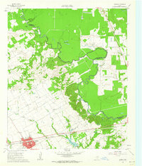
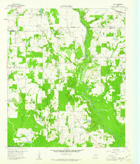 1960 Tool1961 Print · USGSThe rural Henderson County landscape of the early 1960s is preserved here, centered on the creek-fed agricultural lands near the Trinity River. Genealogists and local historians can trace the foundations of Tool, Tolosa, and Aley, alongside family landmarks like Baker Cem and King Cem.3 unique versions available
 - 1960 Map of Mabank, 1961 Print
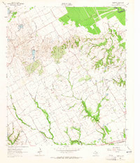
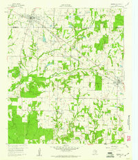 1960 Mabank1961 Print · USGSThe crossroads of Henderson, Kaufman, and Van Zandt counties are captured here in the early sixties, showing a landscape defined by small-town life and the railroad. Genealogists can trace family roots through landmarks like Elam Grove Ch, Mabank Cem, and rural outposts such as Payne Springs.5 unique versions available
 - 1960 Map of Creslenn Ranch, 1961 Print
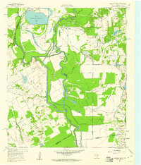 1960 Creslenn Ranch1961 Print · USGSThe Trinity River bottoms and the Cayuga oil country are captured here at the start of the 1960s. Genealogists and local historians can trace the Princeton Cem, the remote Creslenn Ranch, and landmarks like Hall Lake and Trinidad.3 unique versions available
 - 1960 Map of Malakoff, 1961 Print
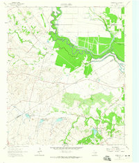
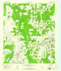 1960 Malakoff1961 Print · USGSThe Trinity River valley in 1960 reveals a landscape of industrial power and small-town growth between Trinidad and Malakoff. Genealogists and historians can trace local landmarks like the St Paul Industrial Sch, Kilman Hospital, and Isaac Cem.4 unique versions available
 - 1961 Map of Kerens, 1962 Print
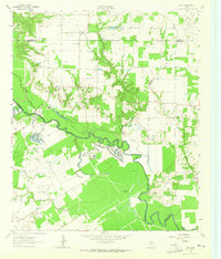
 1961 Kerens1962 Print · USGSKerens and the fertile Trinity River bottomlands are captured here in the early sixties, showing a landscape defined by rail, oil, and water. Genealogists and researchers can locate Oak Grove Ch, the Bazette Oil Field, and family-named water features like Singletary Lake.3 unique versions available
 - 1962 Map of Bazette, 1965 Print
 1962 Bazette1965 Print · USGSThe Trinity River bottomlands and the crossroads of Bazette are captured here in the early sixties. Genealogists and local historians can trace family locations through Phillips Cem, Roane Ch, and the numerous Oil Wells scattered across the prairie.2 unique versions available
 - 1962 Map of Rosser SW, 1965 Print
 1962 Rosser SW1965 Print · USGSNavarro County in the early 1960s was a landscape of rural family farms and emerging water management systems along the Trinity River. Local researchers can locate Rice Cem, the Hopewell Ch, and several named reservoirs along Grays Creek.
 - 1962 Map of Styx, 1965 Print
 1962 Styx1965 Print · USGSHenderson and Kaufman Counties in the early 1960s were defined by the deep bends of the Trinity River and small rural outposts. Researchers can trace family history at Timothy Cem, locate the old Finch Sch, or find the crossroads at Styx.2 unique versions available
 - 1966 Map of Chandler, 1967 Print
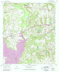 1966 Chandler1967 Print · USGSChandler and the surrounding East Texas countryside are shown in the mid-sixties during the development of Lake Palestine. Researchers can trace old family roots at Macedonia Cem and Sevenleague Cem or locate former community centers like Dixie Sch.3 unique versions available
End of results
Showing maps 1-9 of 9
Top cities of Henderson County
- Athens historical maps
- Gun Barrel City historical maps
- Chandler historical maps
- Tool historical maps
- Malakoff historical maps
- Seven Points historical maps
See more
Frequently asked questions
- What are the different types of historical maps available for Henderson County?
- What is the oldest map of Henderson County?
- Where can I purchase historical maps of Henderson County for my home or office?
- Where can I download high-res historical maps of Henderson County?
- Are there historical topographic maps available for Henderson County?
- Is there historical aerial imagery available for Henderson County?
- Where are historical maps of Henderson County sourced from?