1950s Maps of Henderson County, Texas
Explore 6 historic maps of Henderson County from the 1950s. These maps offer a rare glimpse into what life looked like during the 1950s — showing old roads, neighborhoods, homes, and landmarks that have changed or disappeared over time.
Whether you're researching your family's past, planning a metal detecting trip, or studying how Henderson County's landscape evolved across the 1950s, these high-resolution maps are a powerful tool for exploring the history of this region.
- Focus on a specific era: All maps on this page are from the 1950s, giving you a focused view of this time period.
- See what’s changed: Compare century-old streets, trails, and buildings to today's modern landscape using overlays and satellite layers.
- Research with precision: Use these maps for genealogy, historical research, land use analysis, or educational projects.
- View, download, or print: Maps are fully viewable online in high resolution, and can be downloaded or printed for your own records.
Start exploring Henderson County's history through authentic maps from the 1950s. This is your window into the past.
Henderson County, TX maps
(6)- 1950 Map of Athens
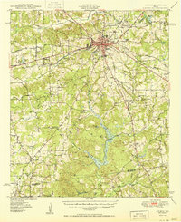 1950 Athens1950 Print · USGSHenderson County center at mid-century, where the rail lines of the St Louis Southwestern and Southern Pacific cross. Genealogists can locate family landmarks like Metzkoff Cem, the Junior College, and Shelby Chapel.
 - 1950 Map of Frankston
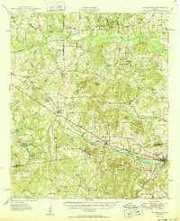 1950 Frankston1950 Print · USGSThe Southern Pacific corridor between Henderson and Anderson Counties comes alive in this mid-century survey. Genealogists and historians can trace family roots at New York and Fincastle, or locate rural landmarks like Central High Sch and Rounsavall Cem.
 - 1954 Map of Dallas, 1963 Print
 1954 Dallas1963 Print · USGSNorth Texas in the mid-fifties and early sixties reveals a landscape of rapid urban growth and water management. Genealogists and historians can trace the evolution of the metroplex through landmarks like Hensley Field, Boles Orphan Home, and the Texas & Pacific RR.4 unique versions available
 - 1956 Map of Tyler
 1956 Tyler1956 Print · USGSEast Texas was a powerhouse of oil production and rail transport during the mid-fifties, centered on the sprawling East Texas Oil Field. Researchers can trace the heritage of industrial hubs like Kilgore, military sites such as the Longhorn Ordnance Works, and many rural landmarks like Mount Enterprise.5 unique versions available
 - 1957 Map of Kemp
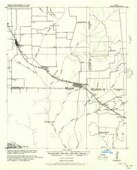 1957 Kemp1957 Print · USGSThe rural borders of Kaufman and Henderson counties come alive in this early twentieth-century survey of the Texas and New Orleans Railroad corridor. Researchers can trace defunct post offices and local landmarks like Ansley and the remote settlement at Prairieville.
 - 1958 Map of Dallas
 1958 Dallas1958 Print · USGSNorth Texas in the late fifties shows the dramatic expansion of the Metroplex as it absorbs surrounding farm towns. Genealogists and historians can trace old rail lines like the Missouri-Kansas-Texas and locate early lakefront developments at Eagle Mountain Lake and Lake Worth Village.
End of results
Showing maps 1-6 of 6
Top cities of Henderson County
- Athens historical maps
- Gun Barrel City historical maps
- Chandler historical maps
- Tool historical maps
- Malakoff historical maps
- Seven Points historical maps
See more
Frequently asked questions
- What are the different types of historical maps available for Henderson County?
- What is the oldest map of Henderson County?
- Where can I purchase historical maps of Henderson County for my home or office?
- Where can I download high-res historical maps of Henderson County?
- Are there historical topographic maps available for Henderson County?
- Is there historical aerial imagery available for Henderson County?
- Where are historical maps of Henderson County sourced from?