1930s Maps of Hood County, Texas
Explore 3 historic maps of Hood County from the 1930s. These maps offer a rare glimpse into what life looked like during the 1930s — showing old roads, neighborhoods, homes, and landmarks that have changed or disappeared over time.
Whether you're researching your family's past, planning a metal detecting trip, or studying how Hood County's landscape evolved across the 1930s, these high-resolution maps are a powerful tool for exploring the history of this region.
- Focus on a specific era: All maps on this page are from the 1930s, giving you a focused view of this time period.
- See what’s changed: Compare century-old streets, trails, and buildings to today's modern landscape using overlays and satellite layers.
- Research with precision: Use these maps for genealogy, historical research, land use analysis, or educational projects.
- View, download, or print: Maps are fully viewable online in high resolution, and can be downloaded or printed for your own records.
Start exploring Hood County's history through authentic maps from the 1930s. This is your window into the past.
Hood County, TX maps
(3)- 1931 Map of Dennis
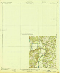 1931 Dennis1931 Print · USGSThe Brazos River winds along the Parker and Hood County line in the 1920s, a landscape defined by riverside homesteads. Genealogists can trace family roots through rural landmarks like Walker Sch, Nightower Bridge, and the community of Robertson.
 - 1931 Map of Santo
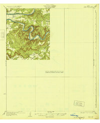 1931 Santo1931 Print · USGSPalo Pinto County in the mid-1920s was a land of winding river valleys and rural schoolhouse communities. Genealogists and historians can trace the early rail-and-river economy through the Texas and Pacific line and the Brazos River, while locating family homesteads near Village Bend Sch or New Hope Sch.3 unique versions available
 - 1931 Map of Tolar
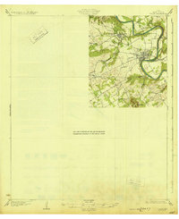 1931 Tolar1931 Print · USGSThe Brazos River valley of Hood County comes alive in this early 1930s survey of the Granbury area. Trace the early layout of Granbury, the route of the Fort Worth and Rio Grande, and rural landmarks like Comanche Peak.2 unique versions available
End of results
Showing maps 1-3 of 3
Top cities of Hood County
Frequently asked questions
- What are the different types of historical maps available for Hood County?
- What is the oldest map of Hood County?
- Where can I purchase historical maps of Hood County for my home or office?
- Where can I download high-res historical maps of Hood County?
- Are there historical topographic maps available for Hood County?
- Is there historical aerial imagery available for Hood County?
- Where are historical maps of Hood County sourced from?