1900s (20th Century) Maps of Hood County, Texas
Explore 37 historic maps of Hood County from the 1900s (20th Century). These maps offer a rare glimpse into what life looked like during the 1900s — showing old roads, neighborhoods, homes, and landmarks that have changed or disappeared over time.
Whether you're researching your family's past, planning a metal detecting trip, or studying how Hood County's landscape evolved across the 1900s, these high-resolution maps are a powerful tool for exploring the history of this region.
- Focus on a specific era: All maps on this page are from the 1900s, giving you a focused view of this time period.
- See what’s changed: Compare century-old streets, trails, and buildings to today's modern landscape using overlays and satellite layers.
- Research with precision: Use these maps for genealogy, historical research, land use analysis, or educational projects.
- View, download, or print: Maps are fully viewable online in high resolution, and can be downloaded or printed for your own records.
Start exploring Hood County's history through authentic maps from the 1900s. This is your window into the past.
Hood County, TX maps
(37)- 1918 Map of Palo Pinto
 1918 Palo Pinto1918 Print · USGSPalo Pinto County and the Brazos River valley appear here in the final year of the Great War, showing a landscape shaped by coal and steam. Genealogists and historians can locate defunct river crossings like Oaks Ferry, early rural education at Marsden School, and the extensive Coal Mines that once powered the regional economy.
 - 1920 Map of Stephenville
 1920 Stephenville1920 Print · USGSErath County thrived at the intersection of three major railroads during the early twentieth century. Genealogists and historians can trace the foundations of Stephenville and Dublin, alongside rural landmarks like Morgan Mill and Tanner School.
 - 1923 Map of Granbury 2-a
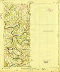
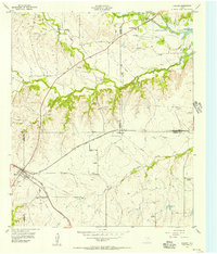
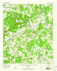
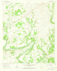
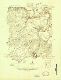 1923 Granbury 2-a1923 Print · USGSHood County in the early 1920s is defined by the winding course of the Brazos River and the arrival of early industrial infrastructure. Researchers can trace rural life at Friendship School, find the old stop at Lambert, and locate landmarks like Comanche Pk.
 - 1923 Map of Granbury 1-b
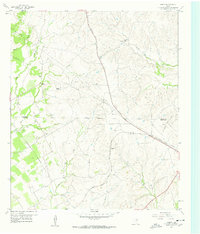
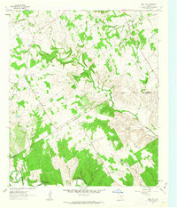
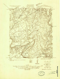 1923 Granbury 1-b1923 Print · USGSHood County in the early twenties reveals a landscape defined by the winding Brazos River and the arrival of early motor highways. Trace family roots and old property lines near Acton, Shady Grove School, and the dramatic river loops at Carmichael Bend.
 - 1924 Map of Weatherford 3-d
 1924 Weatherford 3-d1924 Print · USGSParker and Hood counties are captured here in the mid-1920s as the river-cut landscape began to see early industrial infrastructure. Genealogists can trace early rural life through Walker School, the Hightower Bridge, and several family-named creek branches.
 - 1924 Map of Granbury 1-c
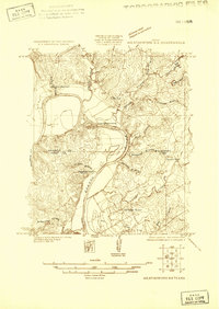
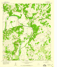
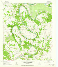
 1924 Granbury 1-c1924 Print · USGSThe Brazos River creates a series of dramatic loops through Somervell and Hood Counties in the mid-1920s. Genealogists and local historians can trace the old community footprints of Mambrino, Nemo, and Georges Creek, alongside rural landmarks like Nubbin Ridge Church.
 - 1928 Map of Godley
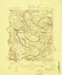
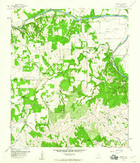
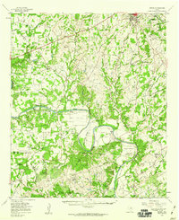
 1928 Godley1928 Print · USGSThe Brazos River winds through Hood and Somervell Counties in the mid-1920s, defining a landscape of deep river bends and rural crossroads. Researchers can locate early educational landmarks like Cordova Bend School and Harmony School, or trace the site of Ft Spunky.2 unique versions available
 - 1931 Map of Dennis
 1931 Dennis1931 Print · USGSThe Brazos River winds along the Parker and Hood County line in the 1920s, a landscape defined by riverside homesteads. Genealogists can trace family roots through rural landmarks like Walker Sch, Nightower Bridge, and the community of Robertson.
 - 1931 Map of Santo
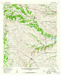
 1931 Santo1931 Print · USGSPalo Pinto County in the mid-1920s was a land of winding river valleys and rural schoolhouse communities. Genealogists and historians can trace the early rail-and-river economy through the Texas and Pacific line and the Brazos River, while locating family homesteads near Village Bend Sch or New Hope Sch.3 unique versions available
 - 1931 Map of Tolar
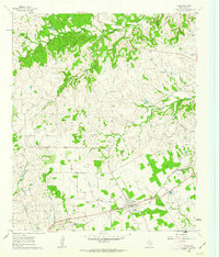
 1931 Tolar1931 Print · USGSThe Brazos River valley of Hood County comes alive in this early 1930s survey of the Granbury area. Trace the early layout of Granbury, the route of the Fort Worth and Rio Grande, and rural landmarks like Comanche Peak.2 unique versions available
 - 1954 Map of Dallas, 1963 Print
 1954 Dallas1963 Print · USGSNorth Texas in the mid-fifties and early sixties reveals a landscape of rapid urban growth and water management. Genealogists and historians can trace the evolution of the metroplex through landmarks like Hensley Field, Boles Orphan Home, and the Texas & Pacific RR.4 unique versions available
 - 1954 Map of Abilene, 1966 Print
 1954 Abilene1966 Print · USGSThe Texas Big Country comes into focus in the mid-1950s as petroleum and new water projects reshape the landscape. Local historians can trace the Butterfield Trail, find the Fort Phantom Hill Ruins, and locate numerous small communities along the Texas & Pacific line.2 unique versions available
 - 1955 Map of Cresson, 1956 Print
 1955 Cresson1956 Print · USGSThe rail junction at Cresson and the rising waters of Benbrook Lake define this mid-century Texas landscape. Genealogists can locate several family-named landmarks and rural burial grounds, including Corn Cem, Day-Radcliff Cemetery, and the Wheatland School.3 unique versions available
 - 1958 Map of Dallas
 1958 Dallas1958 Print · USGSNorth Texas in the late fifties shows the dramatic expansion of the Metroplex as it absorbs surrounding farm towns. Genealogists and historians can trace old rail lines like the Missouri-Kansas-Texas and locate early lakefront developments at Eagle Mountain Lake and Lake Worth Village.
 - 1958 Map of Abilene
 1958 Abilene1958 Print · USGSMid-century West Texas comes alive in this survey of the Abilene and Stephenville region during a period of steady oil expansion and military growth. Genealogists and local historians can trace the paths of the Texas & Pacific RR through historic towns, locate the Fort Griffin Ruins, and find smaller settlements like Desdemona and Lueders.
 - 1958 Map of Chapin, 1960 Print
 1958 Chapin1960 Print · USGSThe Parker and Hood County line in the late fifties was a landscape of working ranches and railroad sidings. Researchers can locate family landmarks such as Baker Cem, the settlement of Chapin, and the Cresson Ranch among the creeks.3 unique versions available
 - 1959 Map of Tin Top, 1960 Print
 1959 Tin Top1960 Print · USGSThe Brazos River loop defines this Parker and Hood County landscape in the late fifties, where rural life focused on tight-knit river valley communities. Genealogists can trace family footprints at Haring Cem, New Prospect Ch, and the settlement of Tin Top.4 unique versions available
 - 1959 Map of Dennis, 1960 Print
 1959 Dennis1960 Print · USGSThe Brazos River valley in Parker and Hood Counties was a landscape of river crossings and family ranchlands in the late 1950s. Genealogists can trace rural life through Holder Cem and Buckner Cem, or locate river fords like Maxwell Crossing.3 unique versions available
 - 1959 Map of Lipan, 1960 Print
 1959 Lipan1960 Print · USGSNear the intersection of four Texas counties in the late fifties, this survey captures the rural character and winding river bends of the Brazos valley. Researchers can locate family landmarks like Evergreen Cem, Dobbs Valley Ch, and the remote Progress Sch.3 unique versions available
 - 1959 Map of Dennis, 1960 Print
 1959 Dennis1960 Print · USGSParker and Hood Counties are shown in the late fifties as the Brazos River meanders through a landscape of historic crossings and valley settlements. Researchers can trace rural lineages through numerous sites like Tin Top Sch, Center Mill, and the Bethel Cem.
 - 1959 Map of Cresson, 1961 Print
 1959 Cresson1961 Print · USGSNorth Texas ranching and rail junctions dominate the landscape in the late fifties as Benbrook Lake takes shape. Genealogists can trace family roots through numerous remote burial grounds like Cresson Cem and Dixon Cem, while rail enthusiasts follow the Texas and Pacific line through Aledo.
 - 1960 Map of Tolar, 1963 Print
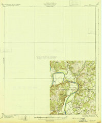
 1960 Tolar1963 Print · USGSHood County, Texas, was a landscape of small family plots and rail-side industry at the dawn of the 1960s. Genealogists and researchers can trace local history through numerous burial sites like Strouds Creek Cemetery and follow the route of the Gulf Colorado and Santa Fe railroad.3 unique versions available
 - 1961 Map of Acton, 1963 Print
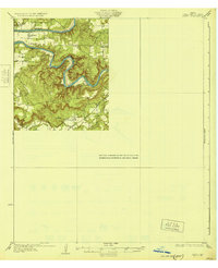
 1961 Acton1963 Print · USGSHood County's river-bottom lands are captured here in the early sixties, centered on the historic community of Acton. Local historians can trace the deep loops of the Brazos River and locate family landmarks like Miller Cem, Acton Ch, and Snider.5 unique versions available
 - 1961 Map of Hill City, 1963 Print
 1961 Hill City1963 Print · USGSCrossing the Hood and Somervell county line in the early sixties, this landscape shows a network of family farms and rural outposts. Researchers can locate the Mt Pleasant Cemetery, the Neri schoolhouse, and the Cedar Brake Girl Scout Camp along the Paluxy River.3 unique versions available
 - 1961 Map of Nemo, 1963 Print
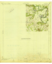
 1961 Nemo1963 Print · USGSThe Brazos River winds through the Hood and Somervell County border in the early sixties, creating a landscape of deep river bends and small rural communities. Genealogists can trace family roots at Mitchell Bend Cem or Oldham Cem, and locate landmarks like Fort Spunkey and Mambrino.3 unique versions available
Showing maps 1-25 of 37
Top cities of Hood County
Frequently asked questions
- What are the different types of historical maps available for Hood County?
- What is the oldest map of Hood County?
- Where can I purchase historical maps of Hood County for my home or office?
- Where can I download high-res historical maps of Hood County?
- Are there historical topographic maps available for Hood County?
- Is there historical aerial imagery available for Hood County?
- Where are historical maps of Hood County sourced from?