1900s (20th Century) Maps of Indian Hot Springs, Texas
Explore 6 historic maps of Indian Hot Springs from the 1900s (20th Century). These maps offer a rare glimpse into what life looked like during the 1900s — showing old roads, neighborhoods, homes, and landmarks that have changed or disappeared over time.
Whether you're researching your family's past, planning a metal detecting trip, or studying how Indian Hot Springs's landscape evolved across the 1900s, these high-resolution maps are a powerful tool for exploring the history of this region.
- Focus on a specific era: All maps on this page are from the 1900s, giving you a focused view of this time period.
- See what’s changed: Compare century-old streets, trails, and buildings to today's modern landscape using overlays and satellite layers.
- Research with precision: Use these maps for genealogy, historical research, land use analysis, or educational projects.
- View, download, or print: Maps are fully viewable online in high resolution, and can be downloaded or printed for your own records.
Start exploring Indian Hot Springs's history through authentic maps from the 1900s. This is your window into the past.
Indian Hot Springs, TX maps
(6)- 1916 Map of Eagle Mountain, 1929 Print
 1916 Eagle Mountain1929 Print · USGSThe Texas-Mexico borderlands come into sharp focus during the 1910s as cavalry units and cattle ranches define the high-desert landscape. Researchers can trace military movements at Troop A Crossing and locate historic outposts like Redlight Ranch and Old Bell Place.
 - 1959 Map of Marfa, 1976 Print
 1959 Marfa1976 Print · USGSThe Trans-Pecos frontier is captured here in the mid-twentieth century as cattle ranching and high-altitude science shaped the landscape. Researchers can trace the Southern Pacific rail line through Valentine or locate remote border outposts like Ruidosa and Indian Hot Springs Resort.2 unique versions available
 - 1965 Map of Marfa
 1965 Marfa1965 Print · USGSBig Bend ranching and high-desert rail travel come together in the 1960s along the Rio Grande and the southern reaches of the Davis Mountains. Researchers can trace the lineage of cattle outfits like Brite Ranch and historic stops like Valentine and Candelaria.
 - 1972 Map of Indian Hot Springs, 1975 Print
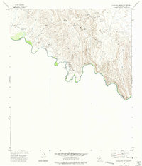 1972 Indian Hot Springs1975 Print · USGSThe Texas-Mexico borderlands come alive in this early 1970s study of the remote Rio Grande corridor. Researchers can trace desert water sources like Indian Hot Springs and Soda Spring or locate landmarks such as Talley Ranch and the nearby Cem.
 - 1984 Map of Indian Hot Springs, 1985 Print
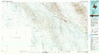
 1984 Indian Hot Springs1985 Print · USGSIn the mid-1980s, the remote borderlands of West Texas remained a territory defined by isolated springs and desert peaks. Researchers can trace the rugged access to Indian Hot Springs and locate historic water points like Eagle Spring and Smugglers Gap.
 - 1993 Map of Indian Hot Springs
 1993 Indian Hot Springs1993 Print · USGSThe Hudspeth County borderlands along the Rio Grande are documented here in the early nineties, showing a landscape defined by mountain peaks and desert springs. Researchers can locate remote sites like Indian Hot Springs and water sources like Red Bull Spring.
End of results
Showing maps 1-6 of 6
Frequently asked questions
- What are the different types of historical maps available for Indian Hot Springs?
- What is the oldest map of Indian Hot Springs?
- Where can I purchase historical maps of Indian Hot Springs for my home or office?
- Where can I download high-res historical maps of Indian Hot Springs?
- Are there historical topographic maps available for Indian Hot Springs?
- Is there historical aerial imagery available for Indian Hot Springs?
- Where are historical maps of Indian Hot Springs sourced from?