1900s (20th Century) Maps of Loma Linda Estates Colonia, Texas
Explore 7 historic maps of Loma Linda Estates Colonia from the 1900s (20th Century). These maps offer a rare glimpse into what life looked like during the 1900s — showing old roads, neighborhoods, homes, and landmarks that have changed or disappeared over time.
Whether you're researching your family's past, planning a metal detecting trip, or studying how Loma Linda Estates Colonia's landscape evolved across the 1900s, these high-resolution maps are a powerful tool for exploring the history of this region.
- Focus on a specific era: All maps on this page are from the 1900s, giving you a focused view of this time period.
- See what’s changed: Compare century-old streets, trails, and buildings to today's modern landscape using overlays and satellite layers.
- Research with precision: Use these maps for genealogy, historical research, land use analysis, or educational projects.
- View, download, or print: Maps are fully viewable online in high resolution, and can be downloaded or printed for your own records.
Start exploring Loma Linda Estates Colonia's history through authentic maps from the 1900s. This is your window into the past.
Loma Linda Estates Colonia, TX maps
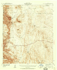
(7)- 1903 Map of Cerro Alto, 1929 Print
 1903 Cerro Alto1929 Print · USGSThe high desert of West Texas and the New Mexico border come alive in this turn-of-the-century survey. Trace early cattle-country water sources like Sparrow Tanks and Coyote Tanks or the peaks of the Hueco Mountains.
 - 1941 Map of Heuco Mountains, 1958 Print
 1941 Heuco Mountains1958 Print · USGSThe rugged Hueco Mountains of West Texas are captured here in the early 1940s, showing a landscape defined by ranching and historic travel routes. Trace the historic Butterfield Trail and locate family landmarks like Helms Ranch and Hueco Inn.2 unique versions available
 - 1943 Map of Heuco Mountains
 1943 Heuco Mountains1943 Print · USGSHudspeth County ranching and desert travel come into focus in the early 1940s as modern highways began to parallel historic wagon routes. Researchers can locate remote family sites like Helms Ranch and Helm Cem or trace the path of the Butterfield Road.
 - 1954 Map of Van Horn, 1964 Print
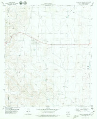
 1954 Van Horn1964 Print · USGSThe Trans-Pecos region of West Texas comes into focus in the mid-1950s as a vital corridor of rail and desert commerce. Researchers can trace the path of the Texas and Pacific through Van Horn or locate remote rail sidings like Borracho and Laska Siding.2 unique versions available
 - 1958 Map of Van Horn
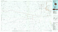
 1958 Van Horn1958 Print · USGSWest Texas ranching and rail history come alive in this 1950s survey of the Trans-Pecos desert during the era of major steam-to-diesel transition. Genealogists and historians can trace family-named outposts like Mayfield Ranch or locate the ruins of Presidio Viejo along the Rio Grande.
 - 1979 Map of Phone Line Canyon
 1979 Phone Line Canyon1979 Print · USGSThe Hueco Mountains of West Texas are captured here in the late seventies, showing a landscape defined by deep canyons and critical desert water tanks. Researchers can trace ranching and utility roots through labels like Phone Line Tank, Dagger Camp, and Powwow Canyon.2 unique versions available
 - 1985 Map of Dell City
 1985 Dell City1985 Print · USGSThe northern Chihuahuan Desert in the mid-1980s reveals a landscape of isolated farming hubs and vast salt basins. Genealogists and researchers can trace the roads and water tanks around Dell City, the remote outpost at Salt Flat, and the rugged slopes of the Sierra Diablo.2 unique versions available
End of results
Showing maps 1-7 of 7
Top cities near Loma Linda Estates Colonia
Frequently asked questions
- What are the different types of historical maps available for Loma Linda Estates Colonia?
- What is the oldest map of Loma Linda Estates Colonia?
- Where can I purchase historical maps of Loma Linda Estates Colonia for my home or office?
- Where can I download high-res historical maps of Loma Linda Estates Colonia?
- Are there historical topographic maps available for Loma Linda Estates Colonia?
- Is there historical aerial imagery available for Loma Linda Estates Colonia?
- Where are historical maps of Loma Linda Estates Colonia sourced from?