1940s Maps of Loma Linda Estates Colonia, Texas
Explore 2 historic maps of Loma Linda Estates Colonia from the 1940s. These maps offer a rare glimpse into what life looked like during the 1940s — showing old roads, neighborhoods, homes, and landmarks that have changed or disappeared over time.
Whether you're researching your family's past, planning a metal detecting trip, or studying how Loma Linda Estates Colonia's landscape evolved across the 1940s, these high-resolution maps are a powerful tool for exploring the history of this region.
- Focus on a specific era: All maps on this page are from the 1940s, giving you a focused view of this time period.
- See what’s changed: Compare century-old streets, trails, and buildings to today's modern landscape using overlays and satellite layers.
- Research with precision: Use these maps for genealogy, historical research, land use analysis, or educational projects.
- View, download, or print: Maps are fully viewable online in high resolution, and can be downloaded or printed for your own records.
Start exploring Loma Linda Estates Colonia's history through authentic maps from the 1940s. This is your window into the past.
Loma Linda Estates Colonia, TX maps
(2)- 1941 Map of Heuco Mountains, 1958 Print
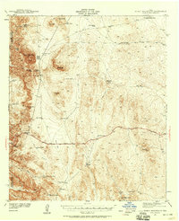 1941 Heuco Mountains1958 Print · USGSThe rugged Hueco Mountains of West Texas are captured here in the early 1940s, showing a landscape defined by ranching and historic travel routes. Trace the historic Butterfield Trail and locate family landmarks like Helms Ranch and Hueco Inn.2 unique versions available
 - 1943 Map of Heuco Mountains
 1943 Heuco Mountains1943 Print · USGSHudspeth County ranching and desert travel come into focus in the early 1940s as modern highways began to parallel historic wagon routes. Researchers can locate remote family sites like Helms Ranch and Helm Cem or trace the path of the Butterfield Road.
End of results
Showing maps 1-2 of 2
Top cities near Loma Linda Estates Colonia
Frequently asked questions
- What are the different types of historical maps available for Loma Linda Estates Colonia?
- What is the oldest map of Loma Linda Estates Colonia?
- Where can I purchase historical maps of Loma Linda Estates Colonia for my home or office?
- Where can I download high-res historical maps of Loma Linda Estates Colonia?
- Are there historical topographic maps available for Loma Linda Estates Colonia?
- Is there historical aerial imagery available for Loma Linda Estates Colonia?
- Where are historical maps of Loma Linda Estates Colonia sourced from?