2020s Maps of Peniel, Greenville
Explore 1 historic maps of Peniel from the 2020s. These maps offer a rare glimpse into what life looked like during the 2020s — showing old roads, neighborhoods, homes, and landmarks that have changed or disappeared over time.
Whether you're researching your family's past, planning a metal detecting trip, or studying how Peniel's landscape evolved across the 2020s, these high-resolution maps are a powerful tool for exploring the history of this region.
- Focus on a specific era: All maps on this page are from the 2020s, giving you a focused view of this time period.
- See what’s changed: Compare century-old streets, trails, and buildings to today's modern landscape using overlays and satellite layers.
- Research with precision: Use these maps for genealogy, historical research, land use analysis, or educational projects.
- View, download, or print: Maps are fully viewable online in high resolution, and can be downloaded or printed for your own records.
Start exploring Peniel's history through authentic maps from the 2020s. This is your window into the past.
Peniel, Greenville maps
(1)- 2022 Map of Greenville NW, 2022 Print
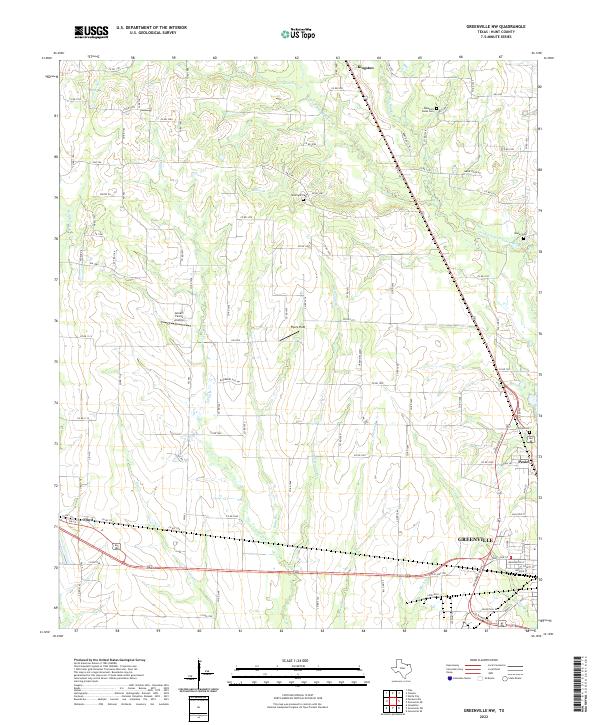 2022 Greenville NW2022 Print · USGSHunt County in the early 2020s shows the continued growth of Greenville and Kingston amidst a network of Sabine River tributaries. Researchers can locate family landmarks like McWright Cem and local flight strips like Flyers Field.
End of results
Showing maps 1-1 of 1
Top cities near Peniel
- Rockwall historical maps
- Greenville historical maps
- Fate historical maps
- Royse City historical maps
- Commerce historical maps
- Josephine historical maps
See more
Frequently asked questions
- What are the different types of historical maps available for Peniel?
- What is the oldest map of Peniel?
- Where can I purchase historical maps of Peniel for my home or office?
- Where can I download high-res historical maps of Peniel?
- Are there historical topographic maps available for Peniel?
- Is there historical aerial imagery available for Peniel?
- Where are historical maps of Peniel sourced from?