1900s (20th Century) Maps of Jacksboro, Texas
Explore 6 historic maps of Jacksboro from the 1900s (20th Century). These maps offer a rare glimpse into what life looked like during the 1900s — showing old roads, neighborhoods, homes, and landmarks that have changed or disappeared over time.
Whether you're researching your family's past, planning a metal detecting trip, or studying how Jacksboro's landscape evolved across the 1900s, these high-resolution maps are a powerful tool for exploring the history of this region.
- Focus on a specific era: All maps on this page are from the 1900s, giving you a focused view of this time period.
- See what’s changed: Compare century-old streets, trails, and buildings to today's modern landscape using overlays and satellite layers.
- Research with precision: Use these maps for genealogy, historical research, land use analysis, or educational projects.
- View, download, or print: Maps are fully viewable online in high resolution, and can be downloaded or printed for your own records.
Start exploring Jacksboro's history through authentic maps from the 1900s. This is your window into the past.
Jacksboro, TX maps
(6)- 1954 Map of Wichita Falls, 1966 Print
 1954 Wichita Falls1966 Print · USGSNorth Texas in the mid-fifties is captured here as a landscape of expanding oil fields and vital rail corridors. Genealogists and historians can trace family roots through rural landmarks like Bacon Chapel and the rail-side growth of Seymour and Archer City.3 unique versions available
 - 1958 Map of Wichita Falls
 1958 Wichita Falls1958 Print · USGSNorth Texas during the late fifties reveals a landscape defined by the booming petroleum industry and established rail hubs. Researchers can trace the development of Wichita Falls and discover rural landmarks like Barton's Chapel or the Hull-Silk Oil Field.
 - 1960 Map of Jacksboro, 1962 Print
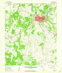 1960 Jacksboro1962 Print · USGSJacksboro was evolving into a regional center during the early 1960s, balancing its frontier heritage with modern industry. Researchers can find deep family roots at Oakwood Cem and Dark Corner Cem or trace the site of Fort Richardson (Historical).3 unique versions available
 - 1961 Map of Jacksboro NE, 1963 Print
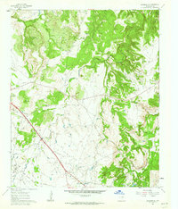 1961 Jacksboro NE1963 Print · USGSJack County's petroleum and transit corridors are well-defined in the early sixties as the energy industry transformed the North Texas landscape. Researchers can trace the Rusmag Oil Field infrastructure, the Carroll Creek (Cem), and the active Chicago Rock Island and Pacific rail line.2 unique versions available
 - 1964 Map of Johnson Lake, 1967 Print
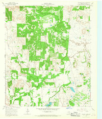 1964 Johnson Lake1967 Print · USGSJack County's oil and gas landscape is captured here during the mid-sixties, showing a countryside where industry met traditional rural life. Family historians and researchers can locate Groves Cem and Patton Cem or trace the West Fork Trinity River and Johnson Lake.
 - 1985 Map of Graham
 1985 Graham1985 Print · USGSNorth Texas in the mid-eighties shows a landscape of growing reservoirs and historic cattle country. Genealogists and historians can trace the foundations of Young County through the Belknap Mountains, Barton Chapel, and the grounds of Fort Richardson State Park.2 unique versions available
End of results
Showing maps 1-6 of 6
Top cities near Jacksboro
Frequently asked questions
- What are the different types of historical maps available for Jacksboro?
- What is the oldest map of Jacksboro?
- Where can I purchase historical maps of Jacksboro for my home or office?
- Where can I download high-res historical maps of Jacksboro?
- Are there historical topographic maps available for Jacksboro?
- Is there historical aerial imagery available for Jacksboro?
- Where are historical maps of Jacksboro sourced from?