
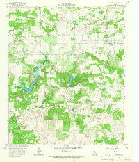
1964 Map of Johnson Lake
USGS Topo · Published 1967About this map
The West Fork Trinity River winds through this section of Jack County, carving a landscape defined by an extensive network of drainage including Jones Creek, Flag Springs Creek, and several branches of Cleveland Creek. By the mid-1960s, this area was heavily shaped by petroleum extraction, as evidenced by a sprawling Oil Field and numerous scattered Oil Wells and Gas Well locations. These industrial features sit alongside rural landmarks that provide significant value for local genealogy, such as Groves Cem and Patton Cem.
Find a feature on this map
20 named features on this map. Tap any name to fly to it.
Don’t see what you’re looking for? This feature index may not catch every label — zoom into the map to look around manually.
Map Details
Editions of this 1964 Johnson Lake Map
This is the sole edition of this map. No revisions or reprints were ever made.
Other maps of this area

1954 · Wichita Falls
USGS Topo · 1:250,000

1958 · Wichita Falls
USGS Topo · 1:250,000

1960 · Jacksboro
USGS Topo · 1:24,000

1961 · Jacksboro NE
USGS Topo · 1:24,000

1962 · Antelope Creek NE
USGS Topo · 1:24,000

1964 · Senate
USGS Topo · 1:24,000

1964 · Cundiff
USGS Topo · 1:24,000

1964 · Lynn Creek
USGS Topo · 1:24,000
1964 · Newport
USGS Topo · 1:24,000

1964 · Antelope
USGS Topo · 1:24,000