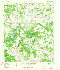
1964 Map of Newport
USGS Topo · Published 1967About this map
The boundary between Clay Co and Jack Co serves as a central divide in this mid-1960s landscape, where the agricultural plains meet the rising elevations of Galliher Mountain. The settlement of Newport sits near the northern edge of the sheet, anchored by the Newport Cem and surrounded by a network of drainage systems including Big Sandy Creek. This period in North Texas was defined by a transition to industrial extraction, evidenced by the numerous Oil Wells scattered across the countryside near smaller communities like Truce and Spradling.
Find a feature on this map
15 named features on this map. Tap any name to fly to it.
Don’t see what you’re looking for? This feature index may not catch every label — zoom into the map to look around manually.
Map Details
Editions of this 1964 Newport Map
This is the sole edition of this map. No revisions or reprints were ever made.
Other maps of this area

1905 · Montague
USGS Topo · 1:125,000

1954 · Sherman
USGS Topo · 1:250,000

1954 · Wichita Falls
USGS Topo · 1:250,000

1958 · Wichita Falls
USGS Topo · 1:250,000

1958 · Sherman
USGS Topo · 1:250,000

1961 · Brushy Mound
USGS Topo · 1:24,000

1961 · Selma
USGS Topo · 1:24,000

1961 · Crafton
USGS Topo · 1:24,000
1963 · Vashti
USGS Topo · 1:24,000

1964 · Cundiff
USGS Topo · 1:24,000