
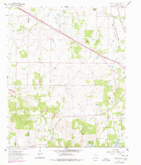
1961 Map of Brushy Mound
USGS Topo · Published 1963About this map
The boundary between Clay Co and Montague Co defines the northwestern corner of this territory, where the cattle-ranching landscape of North Texas meets an emerging industrial economy. The topography is anchored by distinct rises such as Brushy Mound and Dead Ox Mound, providing natural vantage points over a network of waterways including Belknap Creek and the Prairie Branch. By the early 1960s, the southern portion of the map is dominated by the newly formed Lake Amon G Carter, with surrounding lands marked for controlled inundation. This transition from open range to reservoir and resource extraction is underscored by the extensive Boedeker Oil Field and the Bowie Oil Field. Transport infrastructure is dense for the era, with the Chicago Rock Island and Pacific and Fort Worth and Denver railroads cutting across the terrain, while the solitary McDonald Cem offers a grounded point of reference for family historians.
Find a feature on this map
21 named features on this map. Tap any name to fly to it.
Don’t see what you’re looking for? This feature index may not catch every label — zoom into the map to look around manually.
Map Details
Editions of this 1961 Brushy Mound Map
2 editions found
Other maps of this area

1905 · Montague
USGS Topo · 1:125,000

1954 · Sherman
USGS Topo · 1:250,000

1954 · Wichita Falls
USGS Topo · 1:250,000

1958 · Wichita Falls
USGS Topo · 1:250,000

1958 · Sherman
USGS Topo · 1:250,000

1960 · Buzzard Roost Knob
USGS Topo · 1:24,000

1961 · Stoneburg
USGS Topo · 1:24,000

1961 · Selma
USGS Topo · 1:24,000

1961 · Sunset
USGS Topo · 1:24,000

1961 · Bowie
USGS Topo · 1:24,000