
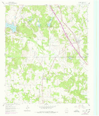
1961 Map of Sunset
USGS Topo · Published 1963About this map
Sunset serves as a central junction on this early 1960s survey, where the Fort Worth and Denver railroad cuts across the landscape. The region is defined by a series of water management projects along the various forks of Big Sandy Creek, including Big Sandy Creek Dam No 11, No 12, and No 13. These structures created controlled inundation areas near the recently established Lake Amon G Carter, a significant water feature in this part of Montague County.
Find a feature on this map
24 named features on this map. Tap any name to fly to it.
Don’t see what you’re looking for? This feature index may not catch every label — zoom into the map to look around manually.
Map Details
Editions of this 1961 Sunset Map
2 editions found
Other maps of this area

1905 · Montague
USGS Topo · 1:125,000

1954 · Sherman
USGS Topo · 1:250,000

1958 · Sherman
USGS Topo · 1:250,000

1961 · Salona
USGS Topo · 1:24,000

1961 · Brushy Mound
USGS Topo · 1:24,000

1961 · Selma
USGS Topo · 1:24,000

1961 · Alvord
USGS Topo · 1:24,000
1961 · Smyrna
USGS Topo · 1:24,000

1961 · Bowie
USGS Topo · 1:24,000

1961 · Crafton
USGS Topo · 1:24,000