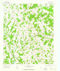
1961 Map of Smyrna
USGS Topo · Published 1963About this map
The boundary between Montague and Wise counties divides this North Texas landscape, where the Aries Caddo Oil Field is marked by numerous oil wells and pipelines. In the early 1960s, the rural community of Smyrna and the nearby Pleasant Hill settlement served as local hubs, while the Fort Worth and Denver (Burlington) railroad cut a path through the western terrain near Big Sandy Creek.
Find a feature on this map
28 named features on this map. Tap any name to fly to it.
Don’t see what you’re looking for? This feature index may not catch every label — zoom into the map to look around manually.
Map Details
Editions of this 1961 Smyrna Map
2 editions found
Other maps of this area

1905 · Montague
USGS Topo · 1:125,000

1954 · Sherman
USGS Topo · 1:250,000

1958 · Sherman
USGS Topo · 1:250,000

1961 · Pecan Creek
USGS Topo · 1:24,000

1961 · Salona
USGS Topo · 1:24,000

1961 · Alvord
USGS Topo · 1:24,000

1961 · New Harp
USGS Topo · 1:24,000

1961 · Sunset
USGS Topo · 1:24,000

1961 · Bowie
USGS Topo · 1:24,000
1961 · Forestburg
USGS Topo · 1:24,000