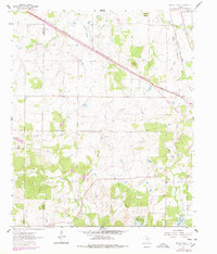
1961 Map of Brushy Mound
USGS Topo · Published 1978About this map
Brushy Mound and Dead Ox Mound rise above a landscape defined by the convergence of rail lines and energy exploration along the Clay and Montague County line. The northern portion of the sheet is bisected by the Fort Worth and Denver railroad, while the Chicago Rock Island and Pacific runs along the eastern edge, tracing the path of Middle Belknap Creek. This era of development is marked by extensive petroleum activity across the Boedeker Oil Field and Osage Oil Field. To the south, the expansion of Lake Amon G Carter reshaped the terrain around the Prairie Branch. Genealogists will find critical landmarks preserved in the locations of McDonald Cem, Prairie Branch Cem, and Brier Creek Cem, which remain as anchors of the earlier rural community structure.
Find a feature on this map
23 named features on this map. Tap any name to fly to it.
Don’t see what you’re looking for? This feature index may not catch every label — zoom into the map to look around manually.
Map Details
Editions of this 1961 Brushy Mound Map
2 editions found
Other maps of this area

1905 · Montague
USGS Topo · 1:125,000

1954 · Sherman
USGS Topo · 1:250,000

1954 · Wichita Falls
USGS Topo · 1:250,000

1958 · Wichita Falls
USGS Topo · 1:250,000

1958 · Sherman
USGS Topo · 1:250,000

1960 · Buzzard Roost Knob
USGS Topo · 1:24,000

1961 · Stoneburg
USGS Topo · 1:24,000

1961 · Brushy Mound
USGS Topo · 1:24,000

1961 · Selma
USGS Topo · 1:24,000

1961 · Sunset
USGS Topo · 1:24,000