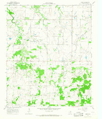
1963 Map of Vashti
USGS Topo · Published 1967About this map
Vashti serves as the primary hub of this 1963 landscape in Clay County, situated at the intersection of local roads and several industrial installations. The terrain is defined by a dense network of watercourses, including the westward-flowing Buffalo Creek and the meandering West Belknap Creek, which suggest a traditional ranching and rural economy. Significant evidence of the era's energy and resource extraction is visible through numerous Oil Wells and a large Pipeline cutting across the central portion of the sheet. For those tracing family history in the area, the Liberty Cem stands as a notable landmark south of the town center, while features like Prairie Spring Branch and several scattered Gravel Pits illustrate how the local geography was utilized for both water access and material mining during the mid-20th century.
Find a feature on this map
12 named features on this map. Tap any name to fly to it.
Don’t see what you’re looking for? This feature index may not catch every label — zoom into the map to look around manually.
Map Details
Editions of this 1963 Vashti Map
This is the sole edition of this map. No revisions or reprints were ever made.
Other maps of this area

1905 · Montague
USGS Topo · 1:125,000

1954 · Sherman
USGS Topo · 1:250,000

1954 · Wichita Falls
USGS Topo · 1:250,000

1958 · Wichita Falls
USGS Topo · 1:250,000

1958 · Sherman
USGS Topo · 1:250,000

1961 · Stoneburg
USGS Topo · 1:24,000

1961 · Brushy Mound
USGS Topo · 1:24,000

1961 · Selma
USGS Topo · 1:24,000
1964 · Newport
USGS Topo · 1:24,000
1964 · Postoak
USGS Topo · 1:24,000