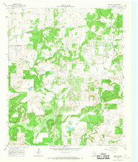
1964 Map of Postoak
USGS Topo · Published 1967About this map
Postoak stands as the primary settlement in this 1960s landscape, positioned near the boundary between Clay Co and Jack Co. The terrain is defined by the hydrological network of the West Fork Trinity River and its tributaries, including Turkey Creek and Jones Creek, which carve through the elevations of Bear Mtn and the quiet expanse of Pudding Valley.
Find a feature on this map
19 named features on this map. Tap any name to fly to it.
Don’t see what you’re looking for? This feature index may not catch every label — zoom into the map to look around manually.
Map Details
Editions of this 1964 Postoak Map
2 editions found
Other maps of this area

1954 · Wichita Falls
USGS Topo · 1:250,000

1958 · Wichita Falls
USGS Topo · 1:250,000

1962 · Antelope Creek NE
USGS Topo · 1:24,000
1963 · Vashti
USGS Topo · 1:24,000

1964 · Cundiff
USGS Topo · 1:24,000

1964 · Johnson Lake
USGS Topo · 1:24,000

1964 · Lynn Creek
USGS Topo · 1:24,000
1964 · Newport
USGS Topo · 1:24,000

1964 · Antelope
USGS Topo · 1:24,000

1964 · Scotland SE
USGS Topo · 1:24,000