1900s (20th Century) Maps of Valentine, Texas
Explore 6 historic maps of Valentine from the 1900s (20th Century). These maps offer a rare glimpse into what life looked like during the 1900s — showing old roads, neighborhoods, homes, and landmarks that have changed or disappeared over time.
Whether you're researching your family's past, planning a metal detecting trip, or studying how Valentine's landscape evolved across the 1900s, these high-resolution maps are a powerful tool for exploring the history of this region.
- Focus on a specific era: All maps on this page are from the 1900s, giving you a focused view of this time period.
- See what’s changed: Compare century-old streets, trails, and buildings to today's modern landscape using overlays and satellite layers.
- Research with precision: Use these maps for genealogy, historical research, land use analysis, or educational projects.
- View, download, or print: Maps are fully viewable online in high resolution, and can be downloaded or printed for your own records.
Start exploring Valentine's history through authentic maps from the 1900s. This is your window into the past.
Valentine, TX maps
(6)- 1943 Map of Valentine
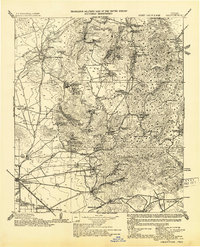 1943 Valentine1943 Print · USGSValentine and the Davis Mountains come alive in this mid-century look at the cattle and rail country of West Texas. Genealogists and historians can trace family-named holdings like Means Ranch Hdqrs., Prude's Ranch, and the isolated Foster Cabin.
 - 1959 Map of Marfa, 1976 Print
 1959 Marfa1976 Print · USGSThe Trans-Pecos frontier is captured here in the mid-twentieth century as cattle ranching and high-altitude science shaped the landscape. Researchers can trace the Southern Pacific rail line through Valentine or locate remote border outposts like Ruidosa and Indian Hot Springs Resort.2 unique versions available
 - 1965 Map of Marfa
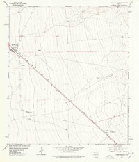
 1965 Marfa1965 Print · USGSBig Bend ranching and high-desert rail travel come together in the 1960s along the Rio Grande and the southern reaches of the Davis Mountains. Researchers can trace the lineage of cattle outfits like Brite Ranch and historic stops like Valentine and Candelaria.
 - 1978 Map of Valentine East
 1978 Valentine East1978 Print · USGSThe high desert of Jeff Davis and Presidio counties comes to life in the late seventies as the rail line connects remote outposts. Trace ranching history through the Bell Place Windmill and family-named spots like Youngblood or Quebec.
 - 1978 Map of Valentine West
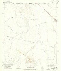 1978 Valentine West1978 Print · USGSJeff Davis and Presidio Counties appear here in the late seventies, centered on the railroad hub of Valentine. Researchers can trace the ranching history of the Trans-Pecos through sites like Roosevelt Ranch, Conring Ranch, and the Southern Pacific line.
 - 1985 Map of Mount Livermore
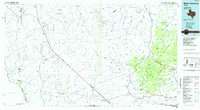 1985 Mount Livermore1985 Print · USGSThe trans-Pecos landscape of the mid-1980s comes to life through this survey of the desert floor and volcanic peaks. Trace the Southern Pacific line past Valentine or locate historic sites like Plata Verde Mines and the McDonald Observatory.3 unique versions available
End of results
Showing maps 1-6 of 6
Frequently asked questions
- What are the different types of historical maps available for Valentine?
- What is the oldest map of Valentine?
- Where can I purchase historical maps of Valentine for my home or office?
- Where can I download high-res historical maps of Valentine?
- Are there historical topographic maps available for Valentine?
- Is there historical aerial imagery available for Valentine?
- Where are historical maps of Valentine sourced from?