1980s Maps of Jefferson County, Texas
Explore 9 historic maps of Jefferson County from the 1980s. These maps offer a rare glimpse into what life looked like during the 1980s — showing old roads, neighborhoods, homes, and landmarks that have changed or disappeared over time.
Whether you're researching your family's past, planning a metal detecting trip, or studying how Jefferson County's landscape evolved across the 1980s, these high-resolution maps are a powerful tool for exploring the history of this region.
- Focus on a specific era: All maps on this page are from the 1980s, giving you a focused view of this time period.
- See what’s changed: Compare century-old streets, trails, and buildings to today's modern landscape using overlays and satellite layers.
- Research with precision: Use these maps for genealogy, historical research, land use analysis, or educational projects.
- View, download, or print: Maps are fully viewable online in high resolution, and can be downloaded or printed for your own records.
Start exploring Jefferson County's history through authentic maps from the 1980s. This is your window into the past.
Jefferson County, TX maps
(9)- 1983 Map of Galveston
 1983 Galveston1983 Print · USGSThe Texas Gulf Coast comes into sharp focus in the early eighties, centered on the thriving maritime and industrial hubs of Galveston and Texas City. Trace coastal change and land use through landmarks like Fort San Jacinto, the Texas City Dike, and the expansive Galveston Island State Park.
 - 1983 Map of Port Arthur
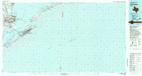
 1983 Port Arthur1983 Print · USGSThe Texas and Louisiana coastline comes into sharp focus during the early 1980s, showcasing the industrial hubs of the Gulf. Trace the development of Port Arthur and Port Neches or locate specific facilities like St Gabriel Hospital and the West Hackberry Oil Field.
 - 1983 Map of Anahuac
 1983 Anahuac1983 Print · USGSThe Upper Texas Coast and its energy-driven landscape are detailed here in the early eighties. Genealogists and historians can trace coastal settlements like Anahuac and Winnie alongside the storied Spindletop Oil Field and the Anahuac National Wildlife Refuge.2 unique versions available
 - 1984 Map of Beaumont
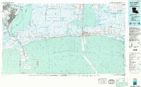
 1984 Beaumont1984 Print · USGSSoutheast Texas in the late seventies and early eighties shows a landscape of expanding reservoirs and deep timber industry. Researchers can trace the development of the Sam Houston National Forest or locate regional landmarks like Grabbs Prairie and the Wynne State Prison Farm.3 unique versions available
 - 1984 Map of Nome, 1985 Print
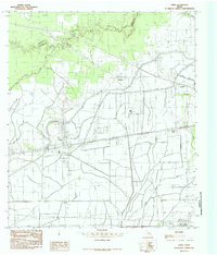
 1984 Nome1985 Print · USGSThe Jefferson and Hardin county line comes alive in the mid-1970s, showing a landscape of coastal prairies and rail-side settlements. Genealogists and local researchers can trace the roads around Nome and Grayburg or locate landmarks like the Southern Pacific line and Swift Prairie.
 - 1984 Map of Bevil Oaks, 1985 Print
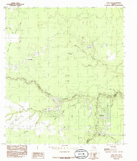 1984 Bevil Oaks1985 Print · USGSSoutheast Texas in the mid-eighties was a landscape where suburban growth at Bevil Oaks met the dense woodlands of the Big Thicket National Preserve. You can trace family-named sites and water features like Pine Ridge, Bonwell, and Fertitta Lake.2 unique versions available
 - 1985 Map of China
 1985 China1985 Print · USGSThe Texas Gulf Coast prairie near China was a landscape of intensive water management and rural settlement in the mid-eighties. Trace the path of the Lower Neches Valley Authority Canal and find old footprints of Westbury, Meeker, and New Bethel.
 - 1986 Map of Beaumont
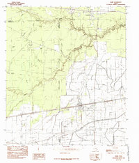
 1986 Beaumont1986 Print · USGSThe East Texas piney woods and coastal prairies are captured here in the mid-eighties, a period of established energy production and conservation. Researchers can trace the industrial footprint of the Oil and Gas Field near Daisetta and Batson, or locate family sites at Graveyard Hill Cem.
 - 1986 Map of Lake Charles
 1986 Lake Charles1986 Print · USGSThe Louisiana-Texas borderlands are captured here in the mid-1980s, showcasing the industrial growth of the Lake Charles region and its rail-linked satellite towns. Trace the evolution of coastal settlements and family landmarks from Sulphur to the Highland Cem.2 unique versions available
End of results
Showing maps 1-9 of 9
Top cities of Jefferson County
- Beaumont historical maps
- Port Arthur historical maps
- Nederland historical maps
- Groves historical maps
- Port Neches historical maps
- Bevil Oaks historical maps
See more
Frequently asked questions
- What are the different types of historical maps available for Jefferson County?
- What is the oldest map of Jefferson County?
- Where can I purchase historical maps of Jefferson County for my home or office?
- Where can I download high-res historical maps of Jefferson County?
- Are there historical topographic maps available for Jefferson County?
- Is there historical aerial imagery available for Jefferson County?
- Where are historical maps of Jefferson County sourced from?