1990s Maps of Jefferson County, Texas
Explore 22 historic maps of Jefferson County from the 1990s. These maps offer a rare glimpse into what life looked like during the 1990s — showing old roads, neighborhoods, homes, and landmarks that have changed or disappeared over time.
Whether you're researching your family's past, planning a metal detecting trip, or studying how Jefferson County's landscape evolved across the 1990s, these high-resolution maps are a powerful tool for exploring the history of this region.
- Focus on a specific era: All maps on this page are from the 1990s, giving you a focused view of this time period.
- See what’s changed: Compare century-old streets, trails, and buildings to today's modern landscape using overlays and satellite layers.
- Research with precision: Use these maps for genealogy, historical research, land use analysis, or educational projects.
- View, download, or print: Maps are fully viewable online in high resolution, and can be downloaded or printed for your own records.
Start exploring Jefferson County's history through authentic maps from the 1990s. This is your window into the past.
Jefferson County, TX maps
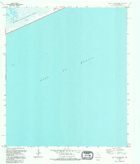
(22)- 1993 Map of Texas Point
 1993 Texas Point1993 Print · USGSThe Texas and Louisiana coastline meets the Gulf in the early 1990s, centering on the vital maritime corridor of Sabine Pass. Researchers can trace harbor infrastructure and coastal conservation lands like Sabine Pass Battleground State Historical Park and the U S Coast Guard Station.
 - 1993 Map of Port Arthur South
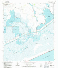
 1993 Port Arthur South1993 Print · USGSJefferson County's industrial coastline and the Sabine Lake marshes are captured in the early nineties, revealing a landscape of heavy shipping and civic life. Trace the local geography from Lincoln High Sch to the expansive J D Murphree Wildlife Management Area.
 - 1993 Map of Voth
 1993 Voth1993 Print · USGSCoastal Texas wetlands and suburban growth meet in the early nineties as the Beaumont area expands northward. Researchers can trace historical footprints through the Arriola Oil Field, the Rosedale Sch, and the winding Neches River.
 - 1993 Map of Pine Forest
 1993 Pine Forest1993 Print · USGSThe Neches River bottomlands and the growth of Vidor define this Southeast Texas landscape in the early nineties. Researchers can trace the layout of Restlawn Memorial Park (Cem), old crossings like Lawson Crossing, and the wild edges of the Big Thicket National Preserve.
 - 1993 Map of Port Arthur North
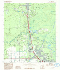
 1993 Port Arthur North1993 Print · USGSThe industrial heart of Southeast Texas comes into focus in the early nineties, showing the maturing street grids of Port Neches and Nederland. Researchers can trace local landmarks like Oak Bluff Memorial Park and the Historical Mansion near the banks of the Neches River.
 - 1993 Map of Sabine Pass
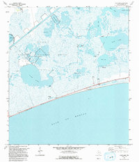
 1993 Sabine Pass1993 Print · USGSIn the early 1990s, the Texas-Louisiana border at Sabine Pass maintained a unique balance of industrial shipping and protected wetlands. Genealogists and researchers can locate the Pace Cem and McGaffey Cem or trace the early reach of Sea Rim State Park.
 - 1993 Map of West of Johnson Bayou
 1993 West of Johnson Bayou1993 Print · USGSThe Louisiana coast near the Texas border appears in the early nineties as a landscape of marsh and ridges. Genealogists and historians can trace the remote Johnson Bayou Landing and family-named landmarks like Garner Ridge and Salt Work Ridge.
 - 1993 Map of West of Greens Bayou
 1993 West of Greens Bayou1993 Print · USGSCoastal Texas and Louisiana are mapped here in the early nineties, showing the industrial waterways and marshlands where the state borders meet. Researchers can trace the dredged paths of the Intracoastal Waterway past Humble Island and into the Sabine National Wildlife Refuge.
 - 1993 Map of Fannett West, 1994 Print
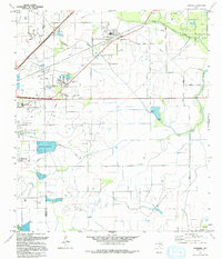
 1993 Fannett West1994 Print · USGSJefferson County as it appeared in the early 1990s was a landscape defined by the intersection of rural ranching and the energy industry. Genealogists and researchers can trace the vicinity of Fannett and Morey, and identify local oil and gas landmarks like Fannett Oil Field.
 - 1993 Map of Big Hill Bayou, 1994 Print
 1993 Big Hill Bayou1994 Print · USGSCoastal Jefferson County in the early nineties reveals a landscape of industrial energy production intertwined with massive wildlife preserves. Researchers can trace the Big Hill Oil Field and Humble Cut alongside protected areas like Sea Rim State Park.
 - 1993 Map of Alligator Hole Marsh, 1994 Print
 1993 Alligator Hole Marsh1994 Print · USGSCoastal Jefferson County in the early nineties shows a landscape deeply integrated with the energy industry and tidal wetlands. Researchers can trace petroleum infrastructure and local landmarks like the Strategic Petroleum Reserve, the Port Arthur Country Club, and the La Belle Oil Field.
 - 1993 Map of Port Acres, 1994 Print
 1993 Port Acres1994 Print · USGSJefferson County in the early nineties shows the heavy industrial and residential footprint of the Texas Gulf Coast. Researchers can trace the legacy of the oil boom through Spindletop and Beaumont Field or find family history at Memory Gardens.
 - 1993 Map of Whites Ranch, 1994 Print
 1993 Whites Ranch1994 Print · USGSCoastal Jefferson County in the early 1990s was a landscape defined by the intersection of wildlife conservation and energy production. Researchers can trace the layout of the Big Hill Oil Field and the expansive Mc Faddin National Wildlife Refuge near Whites Ranch.
 - 1993 Map of Clam Lake, 1994 Print
 1993 Clam Lake1994 Print · USGSCoastal Jefferson County is captured here in the early nineties, revealing a landscape of expansive marshes and state-protected wetlands. Trace the saltwater bayous and remote outposts like Kingfisher Camp, Muskrat Camp, and the Clam Lake Oil Field.
 - 1994 Map of Beaumont East
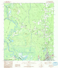
 1994 Beaumont East1994 Print · USGSMid-nineties Beaumont and the Neches River are defined by the legacy of the petroleum industry and rapid urban expansion. Researchers can trace historic neighborhoods and industrial sites from the Spindletop Oil Field to Lamar University and the Magnolia Cemetery.
 - 1994 Map of Mud Lake
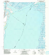
 1994 Mud Lake1994 Print · USGSThe Texas coastline in the mid-nineties reveals a landscape of protected wetlands and vital shipping channels. Researchers can trace the intersection of the Intracoastal Waterway and the expansive Mc Faddin National Wildlife Refuge.
 - 1994 Map of Fannett East
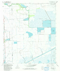
 1994 Fannett East1994 Print · USGSJefferson County's coastal prairie is shown here in the 1990s, where industrial pipelines and oil wells meet traditional ranching and bayou life. Researchers can locate family landmarks like Broussard Cem or trace the early development of Fannett and Cheek.
 - 1994 Map of South of Star Lake
 1994 South of Star Lake1994 Print · USGSThe Jefferson County coast meets the Gulf of Mexico in the mid-nineties, showing a landscape defined by wetlands and industry. Map collectors can trace the maritime boundary of the Mc Faddin National Wildlife Refuge alongside an Oil Well and Pipeline.
 - 1994 Map of Winnie NW
 1994 Winnie NW1994 Print · USGSIn the early nineties, this portion of Jefferson and Liberty Counties shows a landscape defined by coastal bayous and extensive water engineering. Researchers can trace the infrastructure of the Winnie North Base Oil Field and find family-named points like Bauer Ranch and Vogel.
 - 1994 Map of Star Lake
 1994 Star Lake1994 Print · USGSCoastal Jefferson County is captured here in the mid-nineties as a landscape defined by massive petroleum infrastructure and protected wetlands. You can trace the Intracoastal Waterway past the Big Hill Strategic Petroleum Reserve and the expansive Mc Faddin National Wildlife Refuge.
 - 1994 Map of Beaumont West
 1994 Beaumont West1994 Print · USGSThe western suburbs of Beaumont show a complex mix of mid-century growth and industrial infrastructure during the 1990s. Researchers can trace local landmarks like Amelia, the Beaumont Municipal Airport, and the southern routes of the Southern Pacific railroad.
 - 1994 Map of Hamshire
 1994 Hamshire1994 Print · USGSThe coastal prairie of Southeast Texas is captured here in the 1990s, during a period of intensive petroleum production and storage. You can trace the development of Winnie and Hamshire alongside major energy sites like the Strategic Petroleum Reserve Big Hill and the Fannett Oil Field.
End of results
Showing maps 1-22 of 22
Top cities of Jefferson County
- Beaumont historical maps
- Port Arthur historical maps
- Nederland historical maps
- Groves historical maps
- Port Neches historical maps
- Bevil Oaks historical maps
See more
Frequently asked questions
- What are the different types of historical maps available for Jefferson County?
- What is the oldest map of Jefferson County?
- Where can I purchase historical maps of Jefferson County for my home or office?
- Where can I download high-res historical maps of Jefferson County?
- Are there historical topographic maps available for Jefferson County?
- Is there historical aerial imagery available for Jefferson County?
- Where are historical maps of Jefferson County sourced from?