1970s Maps of Jim Wells County, Texas
Explore 6 historic maps of Jim Wells County from the 1970s. These maps offer a rare glimpse into what life looked like during the 1970s — showing old roads, neighborhoods, homes, and landmarks that have changed or disappeared over time.
Whether you're researching your family's past, planning a metal detecting trip, or studying how Jim Wells County's landscape evolved across the 1970s, these high-resolution maps are a powerful tool for exploring the history of this region.
- Focus on a specific era: All maps on this page are from the 1970s, giving you a focused view of this time period.
- See what’s changed: Compare century-old streets, trails, and buildings to today's modern landscape using overlays and satellite layers.
- Research with precision: Use these maps for genealogy, historical research, land use analysis, or educational projects.
- View, download, or print: Maps are fully viewable online in high resolution, and can be downloaded or printed for your own records.
Start exploring Jim Wells County's history through authentic maps from the 1970s. This is your window into the past.
Jim Wells County, TX maps
(6)- 1979 Map of Agua Dulce
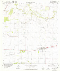 1979 Agua Dulce1979 Print · USGSThe high-production oil fields and rail junctions near the Jim Wells and Nueces county line are on display in the late 1970s. Trace the energy infrastructure of the Agua Dulce Oil Field and the rail corridors of the Texas Mexican through Agua Dulce and Bentonville.
 - 1979 Map of Kingsville NW
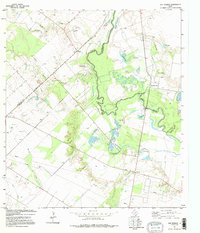
 1979 Kingsville NW1979 Print · USGSCoastal prairie industry meets the ranching tradition in South Texas during the late seventies. Genealogists and industrial historians can trace the intersection of three counties and locate landmarks like Magnolia Windmill, the Agua Dulce Oil and Gas Field, and San Fernando Creek.
 - 1979 Map of Mathis
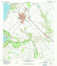 1979 Mathis1979 Print · USGSMathis and the Nueces River valley are shown in the late seventies as a vital rail and water hub. Genealogists can trace local roots at Mathis Cemetery and Descanso Eterno Cemetery or locate old school sites like Weber School.
 - 1979 Map of Sandia
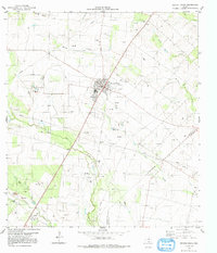
 1979 Sandia1979 Print · USGSThe South Texas Brush Country meets the shores of the Nueces River in the late seventies. Genealogists and historians can trace the legacy of the region through the Old Casa Blanca Fort, the Wade Cem, and the rail-side community of Sandia.
 - 1979 Map of Orange Grove, 1991 Print
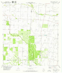
 1979 Orange Grove1991 Print · USGSOrange Grove and the Jim Wells County hinterlands are documented here in the late seventies as the regional oil and gas industry expanded. Genealogists can trace family landmarks like Mc Neill Cem and Reynolds Cem or the settlement of Alfred.
 - 1979 Map of San Patricio, 1995 Print
 1979 San Patricio1995 Print · USGSThe Nueces River valley in the late 1970s remains a landscape of historical depth and rural industry. Genealogists and historians can trace old property lines and landmarks like Fort Lipantitlan, Bluntzer, and the Old San Patricio Cem.
End of results
Showing maps 1-6 of 6
Top cities of Jim Wells County
Frequently asked questions
- What are the different types of historical maps available for Jim Wells County?
- What is the oldest map of Jim Wells County?
- Where can I purchase historical maps of Jim Wells County for my home or office?
- Where can I download high-res historical maps of Jim Wells County?
- Are there historical topographic maps available for Jim Wells County?
- Is there historical aerial imagery available for Jim Wells County?
- Where are historical maps of Jim Wells County sourced from?