1800s (19th Century) Maps of Johnson County, Texas
Explore 6 historic maps of Johnson County from the 1800s (19th Century). These maps offer a rare glimpse into what life looked like during the 1800s — showing old roads, neighborhoods, homes, and landmarks that have changed or disappeared over time.
Whether you're researching your family's past, planning a metal detecting trip, or studying how Johnson County's landscape evolved across the 1800s, these high-resolution maps are a powerful tool for exploring the history of this region.
- Focus on a specific era: All maps on this page are from the 1800s, giving you a focused view of this time period.
- See what’s changed: Compare century-old streets, trails, and buildings to today's modern landscape using overlays and satellite layers.
- Research with precision: Use these maps for genealogy, historical research, land use analysis, or educational projects.
- View, download, or print: Maps are fully viewable online in high resolution, and can be downloaded or printed for your own records.
Start exploring Johnson County's history through authentic maps from the 1800s. This is your window into the past.
Johnson County, TX maps
(6)- 1889 Map of Granbury
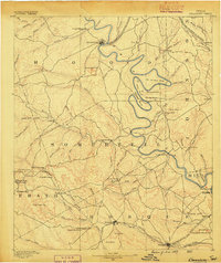 1889 Granbury1889 Print · USGSIn the late 1880s, the Brazos River dictated the life and travel of North Texas, carving deep bends through Hood and Somervell counties. Genealogists and historians can trace early settlements like Fort Spunky and Glenrose or the routes of the Texas Central Railroad.6 unique versions available
 - 1891 Map of Weatherford
 1891 Weatherford1891 Print · USGSParker County and the surrounding ranchlands are shown here in the 1890s as the rail network transformed the region. Researchers can trace early river transport at Powell Ferry or locate vanished sites like Veal Station, Center Mill, and the Bear Creek P.O.
 - 1891 Map of Cleburne
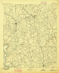
 1891 Cleburne1891 Print · USGSNorth Texas in the late nineteenth century was a land transformed by new iron rails and established river crossings. Genealogists and researchers can trace the early footprints of Cleburne and Hillsboro alongside vanished stops like Port Graham and Files Valley.
 - 1893 Map of Weatherford
 1893 Weatherford1893 Print · USGSParker County was at a pivotal turning point in the late nineteenth century as railroads began to stitch together the North Texas cattle country. Genealogists and local historians can trace early crossings like Powell Ferry and landmarks like Center Mill or Veal Station.5 unique versions available
 - 1894 Map of Cleburne
 1894 Cleburne1894 Print · USGSNorth Central Texas was a burgeoning rail and cattle hub in the late nineteenth century. Genealogists and historians can trace the growth of Cleburne and Hillsboro alongside vanished river landings like Fort Graham and Kimball on the Brazos River.5 unique versions available
 - 1894 Map of Fort Worth, 1918 Print
 1894 Fort Worth1918 Print · USGSNorth Texas at the end of the nineteenth century centers on a burgeoning Fort Worth and its strategic rail junctions. Researchers can locate early township sites like Johnson Station and Birdville or trace the military footprint of Camp Bowie.3 unique versions available
End of results
Showing maps 1-6 of 6
Top cities of Johnson County
- Burleson historical maps
- Cleburne historical maps
- Joshua historical maps
- Keene historical maps
- Venus historical maps
- Alvarado historical maps
See more
Frequently asked questions
- What are the different types of historical maps available for Johnson County?
- What is the oldest map of Johnson County?
- Where can I purchase historical maps of Johnson County for my home or office?
- Where can I download high-res historical maps of Johnson County?
- Are there historical topographic maps available for Johnson County?
- Is there historical aerial imagery available for Johnson County?
- Where are historical maps of Johnson County sourced from?