1990s Maps of Kaufman County, Texas
Explore 2 historic maps of Kaufman County from the 1990s. These maps offer a rare glimpse into what life looked like during the 1990s — showing old roads, neighborhoods, homes, and landmarks that have changed or disappeared over time.
Whether you're researching your family's past, planning a metal detecting trip, or studying how Kaufman County's landscape evolved across the 1990s, these high-resolution maps are a powerful tool for exploring the history of this region.
- Focus on a specific era: All maps on this page are from the 1990s, giving you a focused view of this time period.
- See what’s changed: Compare century-old streets, trails, and buildings to today's modern landscape using overlays and satellite layers.
- Research with precision: Use these maps for genealogy, historical research, land use analysis, or educational projects.
- View, download, or print: Maps are fully viewable online in high resolution, and can be downloaded or printed for your own records.
Start exploring Kaufman County's history through authentic maps from the 1990s. This is your window into the past.
Kaufman County, TX maps
(2)- 1995 Map of Mesquite, 2002 Print
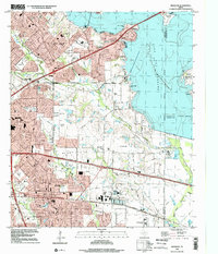 1995 Mesquite2002 Print · USGSMesquite and Garland expand toward the shores of Lake Ray Hubbard during the mid-nineties as suburban development meets older rural settlements. Researchers can trace the evolution of local landmarks from Rose Hill Church to the Long Creek Cemetery and Town East Mall.
 - 1995 Map of Forney North, 2002 Print
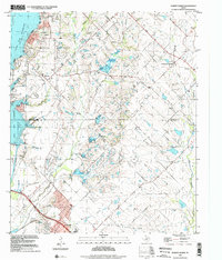 1995 Forney North2002 Print · USGSThe outskirts of Dallas saw rapid transformation in the mid-nineties as suburban growth pushed into Kaufman and Rockwall Counties. Researchers can trace the heritage of early settlers at Peek Cem, Chisholm Cem, and the historic Mt Rose Ch.
End of results
Showing maps 1-2 of 2
Top cities of Kaufman County
- Forney historical maps
- Terrell historical maps
- Heartland historical maps
- Kaufman historical maps
- Crandall historical maps
- Talty historical maps
See more
Frequently asked questions
- What are the different types of historical maps available for Kaufman County?
- What is the oldest map of Kaufman County?
- Where can I purchase historical maps of Kaufman County for my home or office?
- Where can I download high-res historical maps of Kaufman County?
- Are there historical topographic maps available for Kaufman County?
- Is there historical aerial imagery available for Kaufman County?
- Where are historical maps of Kaufman County sourced from?