1900s (20th Century) Maps of Wayside, Texas
Explore 5 historic maps of Wayside from the 1900s (20th Century). These maps offer a rare glimpse into what life looked like during the 1900s — showing old roads, neighborhoods, homes, and landmarks that have changed or disappeared over time.
Whether you're researching your family's past, planning a metal detecting trip, or studying how Wayside's landscape evolved across the 1900s, these high-resolution maps are a powerful tool for exploring the history of this region.
- Focus on a specific era: All maps on this page are from the 1900s, giving you a focused view of this time period.
- See what’s changed: Compare century-old streets, trails, and buildings to today's modern landscape using overlays and satellite layers.
- Research with precision: Use these maps for genealogy, historical research, land use analysis, or educational projects.
- View, download, or print: Maps are fully viewable online in high resolution, and can be downloaded or printed for your own records.
Start exploring Wayside's history through authentic maps from the 1900s. This is your window into the past.
Wayside, TX maps
(5)- 1954 Map of Lubbock, 1958 Print
 1954 Lubbock1958 Print · USGSThe High Plains and Caprock region of West Texas come alive in the mid-1950s, showing a landscape defined by oil discovery and the Brazos River headwaters. Genealogists and historians can trace rail-connected towns like Roaring Springs, find the Pleasant Valley church, or locate family-named landmarks such as Soldier Mound.4 unique versions available
 - 1957 Map of New Home, 1958 Print
 1957 New Home1958 Print · USGSThe rural High Plains of West Texas are meticulously detailed in the late 1950s, showing the early infrastructure of several crossroads communities. Genealogists and researchers can locate landmarks like Dixie Sch (Aband), the settlement of Slide, and the Athletic Field at New Home.
 - 1976 Map of New Home SE, 1978 Print
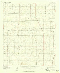
 1976 New Home SE1978 Print · USGSLynn County agriculture and the rural crossroads of Wayside are captured in high detail during the mid-seventies. Genealogists and local historians can trace exact property lines, field patterns, and the small cluster of structures at Wayside.
 - 1985 Map of New Home SE
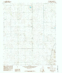 1985 New Home SE1985 Print · USGSLynn County at the mid-eighties reveals a landscape of high-plains agriculture and vital energy infrastructure. Researchers can trace the layout of Wayside, identify specific Well sites, and follow the paths of a major Pipeline and Aqueduct.
 - 1986 Map of Slaton
 1986 Slaton1986 Print · USGSThe Llano Estacado meets the rolling breaks of the Brazos River in the mid-1980s as the region's ranching and rail roots remain visible. Trace the path of the Atchison Topeka and Santa Fe through Post or locate Guthrie Lake and Wilson.2 unique versions available
End of results
Showing maps 1-5 of 5
Top cities near Wayside
- Lubbock historical maps
- Slaton historical maps
- Wolfforth historical maps
- Tahoka historical maps
- Ransom Canyon historical maps
- Wilson historical maps
See more
Frequently asked questions
- What are the different types of historical maps available for Wayside?
- What is the oldest map of Wayside?
- Where can I purchase historical maps of Wayside for my home or office?
- Where can I download high-res historical maps of Wayside?
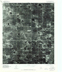
- Are there historical topographic maps available for Wayside?
- Is there historical aerial imagery available for Wayside?
- Where are historical maps of Wayside sourced from?