1960s Maps of Mason, Texas
Explore 3 historic maps of Mason from the 1960s. These maps offer a rare glimpse into what life looked like during the 1960s — showing old roads, neighborhoods, homes, and landmarks that have changed or disappeared over time.
Whether you're researching your family's past, planning a metal detecting trip, or studying how Mason's landscape evolved across the 1960s, these high-resolution maps are a powerful tool for exploring the history of this region.
- Focus on a specific era: All maps on this page are from the 1960s, giving you a focused view of this time period.
- See what’s changed: Compare century-old streets, trails, and buildings to today's modern landscape using overlays and satellite layers.
- Research with precision: Use these maps for genealogy, historical research, land use analysis, or educational projects.
- View, download, or print: Maps are fully viewable online in high resolution, and can be downloaded or printed for your own records.
Start exploring Mason's history through authentic maps from the 1960s. This is your window into the past.
Mason, TX maps
(3)- 1962 Map of Purdy Hill, 1964 Print
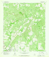 1962 Purdy Hill1964 Print · USGSMason and the surrounding ranchlands are captured here in the early sixties, showing the town's expansion toward the Mason Mountains. Genealogists can locate family burial sites like Behrens Cem and Crosby Cem, or trace the settlement at Koockville.2 unique versions available
 - 1967 Map of Mason, 1970 Print
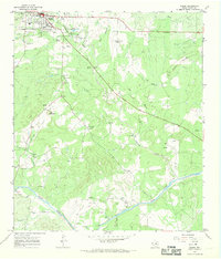 1967 Mason1970 Print · USGSThe Texas Hill Country town of Mason and its surrounding ranch lands are captured here in the late sixties. Genealogists and local historians can trace family-named sites such as Hick Springs, Grossville, and various Cem locations along the Llano River.2 unique versions available
 - 1968 Map of Turtle Creek, 1970 Print
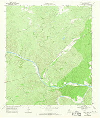 1968 Turtle Creek1970 Print · USGSThe Hill Country of Mason County is defined by the confluence of the Llano River and the James River during the late 1960s. Trace ranching history and early industry through sites like the Cem, the winding James River Road, and scattered Gravel Pits.2 unique versions available
End of results
Showing maps 1-3 of 3
Frequently asked questions
- What are the different types of historical maps available for Mason?
- What is the oldest map of Mason?
- Where can I purchase historical maps of Mason for my home or office?
- Where can I download high-res historical maps of Mason?
- Are there historical topographic maps available for Mason?
- Is there historical aerial imagery available for Mason?
- Where are historical maps of Mason sourced from?