1970s Maps of McCulloch County, Texas
Explore 13 historic maps of McCulloch County from the 1970s. These maps offer a rare glimpse into what life looked like during the 1970s — showing old roads, neighborhoods, homes, and landmarks that have changed or disappeared over time.
Whether you're researching your family's past, planning a metal detecting trip, or studying how McCulloch County's landscape evolved across the 1970s, these high-resolution maps are a powerful tool for exploring the history of this region.
- Focus on a specific era: All maps on this page are from the 1970s, giving you a focused view of this time period.
- See what’s changed: Compare century-old streets, trails, and buildings to today's modern landscape using overlays and satellite layers.
- Research with precision: Use these maps for genealogy, historical research, land use analysis, or educational projects.
- View, download, or print: Maps are fully viewable online in high resolution, and can be downloaded or printed for your own records.
Start exploring McCulloch County's history through authentic maps from the 1970s. This is your window into the past.
McCulloch County, TX maps
(13)- 1970 Map of Needle Creek, 1973 Print
 1970 Needle Creek1973 Print · USGSThe rolling ranchlands where McCulloch, Concho, and Menard counties meet are captured here in the early 1970s. Researchers can trace land use through landmarks like the Ford Ranch, the AT&SF rail line, and family-named water sources like Bee Gum Tank.2 unique versions available
 - 1970 Map of Calf Creek, 1973 Print
 1970 Calf Creek1973 Print · USGSCentral Texas ranch land at the turn of the 1970s is defined by the winding San Saba River. Researchers can trace old river crossings like Twentymile Crossing and locate isolated landmarks like the Block House Ranch and Blue Hole.2 unique versions available
 - 1970 Map of Katemcy, 1973 Print
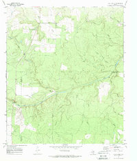
 1970 Katemcy1973 Print · USGSMason and McCulloch counties are captured here in the early 1970s, showing a landscape defined by the San Saba River and small rural outposts. Researchers can trace family history at the Camp San Saba Cem and locate historic community centers like Bethel Ch or Katemcy.2 unique versions available
 - 1970 Map of Brady South, 1973 Print
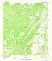
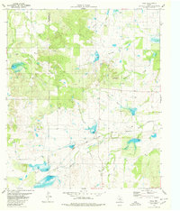
 1970 Brady South1973 Print · USGSMcCulloch County in the early seventies shows the southward expansion of Brady toward the San Saba River. Researchers can trace old rail lines like the Atchison Topeka and Santa Fe or locate the rural South China Sch.2 unique versions available
 - 1970 Map of Robbers Roost, 1973 Print
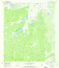
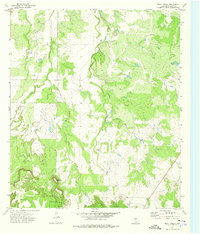
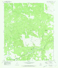 1970 Robbers Roost1973 Print · USGSThe San Saba River valley in Menard and McCulloch counties is captured here in the early 1970s, revealing a landscape of winding watercourses and rural landmarks. Genealogists and historians can trace family-named sites like Hext Cem, Wilkerson Draw, and the Robbers Roost Campground.
 - 1973 Map of Fife, 1976 Print
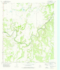
 1973 Fife1976 Print · USGSThe Colorado River corridor near the McCulloch and Coleman county line comes into focus in the early 1970s. Trace local family history at the Marion Cem and Chaffin Cem, or locate old river landmarks like Hays Crossing and the settlement of Waldrip.
 - 1973 Map of Lohn, 1976 Print
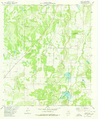
 1973 Lohn1976 Print · USGSIn the early 1970s, the rural reaches of McCulloch County were defined by small ranching hubs and the northern edges of the Brady Mountains. Trace family roots and land plots through Lohn, Pear Valley, and Broadmore, or locate historic landmarks like Lohn Cem.
 - 1973 Map of Whon, 1976 Print
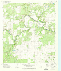
 1973 Whon1976 Print · USGSThe rural border of Coleman and McCulloch Counties comes to life in the early 1970s as the COLORADO RIVER snakes past Parks Mountain. Genealogists and historians can trace old river fords like Mitchell Crossing and Walker Crossing or locate family plots at Whon Cem.2 unique versions available
 - 1973 Map of Bluff Creek, 1976 Print
 1973 Bluff Creek1976 Print · USGSMcCulloch County in the early seventies shows a rugged ranching landscape defined by the elevations of the Brady Mountains. Researchers can trace old water sources and land use through landmarks like Table Top Mountain, China Tank, and early Gas Wells.
 - 1979 Map of Placid, 1980 Print
 1979 Placid1980 Print · USGSMcCulloch County ranching and rugged topography are frozen in time here during the late seventies. Researchers can locate the rural hub of Placid and trace land features like the Landing Strip, Herberg Lake, and the high ground of Packsaddle Hill.
 - 1979 Map of Elm Grove, 1980 Print
 1979 Elm Grove1980 Print · USGSThe ranchlands of San Saba, McCulloch, and Brown counties come into focus in the late 1970s as the Colorado River meanders through the brushy hills. Researchers can locate the Beasley Cemetery, the Elm Grove Ch, and the rural Rodeo Ground.
 - 1979 Map of Mercury, 1980 Print
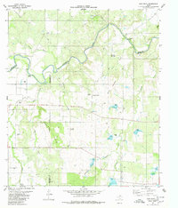
 1979 Mercury1980 Print · USGSThe ranchlands of McCulloch and Coleman counties meet at the winding Colorado River in the late seventies. Genealogists and historians can locate family sites near the Winchell Cem, the small community of Mercury, and an Old Railroad Grade.2 unique versions available
 - 1979 Map of Hall, 1980 Print
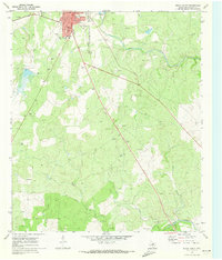
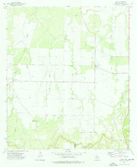
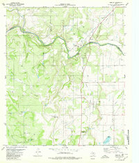
 1979 Hall1980 Print · USGSSan Saba and McCulloch counties are captured in the late seventies, showing a landscape defined by ranching and the railroad. Genealogists can locate family landmarks like Cowboy Cem and trace the Atchison Topeka and Santa Fe line through Hall.
End of results
Showing maps 1-13 of 13
Top cities of McCulloch County
Frequently asked questions
- What are the different types of historical maps available for McCulloch County?
- What is the oldest map of McCulloch County?
- Where can I purchase historical maps of McCulloch County for my home or office?
- Where can I download high-res historical maps of McCulloch County?
- Are there historical topographic maps available for McCulloch County?
- Is there historical aerial imagery available for McCulloch County?
- Where are historical maps of McCulloch County sourced from?