1920s Maps of Ocee, Texas
Explore 2 historic maps of Ocee from the 1920s. These maps offer a rare glimpse into what life looked like during the 1920s — showing old roads, neighborhoods, homes, and landmarks that have changed or disappeared over time.
Whether you're researching your family's past, planning a metal detecting trip, or studying how Ocee's landscape evolved across the 1920s, these high-resolution maps are a powerful tool for exploring the history of this region.
- Focus on a specific era: All maps on this page are from the 1920s, giving you a focused view of this time period.
- See what’s changed: Compare century-old streets, trails, and buildings to today's modern landscape using overlays and satellite layers.
- Research with precision: Use these maps for genealogy, historical research, land use analysis, or educational projects.
- View, download, or print: Maps are fully viewable online in high resolution, and can be downloaded or printed for your own records.
Start exploring Ocee's history through authentic maps from the 1920s. This is your window into the past.
Ocee, TX maps
(2)- 1920 Map of Waco
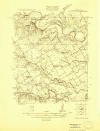
 1920 Waco1920 Print · USGSWaco and its surrounding rail corridors are captured in high detail shortly after the first World War. Researchers can trace the legacy of Rifle Range Camp MacArthur and vanished river crossings like Greenwoods Ferry and Old Towash.
 - 1924 Map of Waco 3-d
 1924 Waco 3-d1924 Print · USGSMcLennan County in the mid-twenties shows a landscape of river fords and emerging petroleum sites. Genealogists can locate family landmarks like Lone Hill Church or Windsor and trace old river routes through Lowell Crossing and the South Bosque Oil Fields.
End of results
Showing maps 1-2 of 2
Top cities near Ocee
- Waco historical maps
- Hewitt historical maps
- Robinson historical maps
- Woodway historical maps
- McGregor historical maps
- Clifton historical maps
See more
Frequently asked questions
- What are the different types of historical maps available for Ocee?
- What is the oldest map of Ocee?
- Where can I purchase historical maps of Ocee for my home or office?
- Where can I download high-res historical maps of Ocee?
- Are there historical topographic maps available for Ocee?
- Is there historical aerial imagery available for Ocee?
- Where are historical maps of Ocee sourced from?