1960s Maps of Devine, Texas
Explore 2 historic maps of Devine from the 1960s. These maps offer a rare glimpse into what life looked like during the 1960s — showing old roads, neighborhoods, homes, and landmarks that have changed or disappeared over time.
Whether you're researching your family's past, planning a metal detecting trip, or studying how Devine's landscape evolved across the 1960s, these high-resolution maps are a powerful tool for exploring the history of this region.
- Focus on a specific era: All maps on this page are from the 1960s, giving you a focused view of this time period.
- See what’s changed: Compare century-old streets, trails, and buildings to today's modern landscape using overlays and satellite layers.
- Research with precision: Use these maps for genealogy, historical research, land use analysis, or educational projects.
- View, download, or print: Maps are fully viewable online in high resolution, and can be downloaded or printed for your own records.
Start exploring Devine's history through authentic maps from the 1960s. This is your window into the past.
Devine, TX maps
(2)- 1964 Map of Ghost Hill, 1966 Print
 1964 Ghost Hill1966 Print · USGSSouthern Frio County comes to life in the mid-1960s, showing a landscape defined by the intersection of the cattle industry and the energy boom. Genealogists and historians can trace family land at Moore Cem or study the reach of the Big Foot Gas Field and the Missouri Pacific railroad.2 unique versions available
 - 1964 Map of Devine, 1966 Print
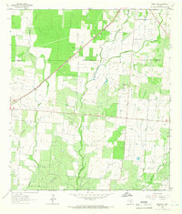
 1964 Devine1966 Print · USGSDevine and the surrounding Medina County countryside are captured here in the mid-1960s as a thriving rail and agricultural hub. Genealogists and researchers can locate family sites at Roberson Cem, trace the Missouri Pacific line, or find the Medina Lake State Fish Hatchery.2 unique versions available
End of results
Showing maps 1-2 of 2
Top cities near Devine
- San Antonio historical maps
- Hondo historical maps
- Castroville historical maps
- Lytle historical maps
- Natalia historical maps
Frequently asked questions
- What are the different types of historical maps available for Devine?
- What is the oldest map of Devine?
- Where can I purchase historical maps of Devine for my home or office?
- Where can I download high-res historical maps of Devine?
- Are there historical topographic maps available for Devine?
- Is there historical aerial imagery available for Devine?
- Where are historical maps of Devine sourced from?