1900s (20th Century) Maps of Cummins Crossing, Texas
Explore 5 historic maps of Cummins Crossing from the 1900s (20th Century). These maps offer a rare glimpse into what life looked like during the 1900s — showing old roads, neighborhoods, homes, and landmarks that have changed or disappeared over time.
Whether you're researching your family's past, planning a metal detecting trip, or studying how Cummins Crossing's landscape evolved across the 1900s, these high-resolution maps are a powerful tool for exploring the history of this region.
- Focus on a specific era: All maps on this page are from the 1900s, giving you a focused view of this time period.
- See what’s changed: Compare century-old streets, trails, and buildings to today's modern landscape using overlays and satellite layers.
- Research with precision: Use these maps for genealogy, historical research, land use analysis, or educational projects.
- View, download, or print: Maps are fully viewable online in high resolution, and can be downloaded or printed for your own records.
Start exploring Cummins Crossing's history through authentic maps from the 1900s. This is your window into the past.
Cummins Crossing, TX maps
(5)- 1910 Map of Buckholts, 1911 Print
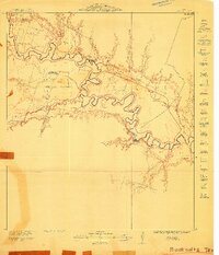 1910 Buckholts1911 Print · USGSThe Milam County bottomlands along the Little River appear here just before major levee projects reshaped the valley. Trace family homesteads and crossings like the Live Oak School, Bryant Station Bridge, and Nielson Farm.
 - 1912 Map of Buckholts
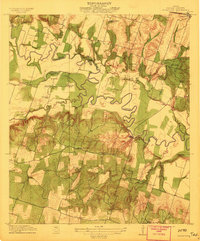 1912 Buckholts1912 Print · USGSMilam County was a landscape of river-bottom farms and rural school districts in the years before the Great War. You can trace early family holdings like Stink Hill Farm and find community landmarks such as Friendship Church and the Wire Bridge.
 - 1954 Map of Austin, 1964 Print
 1954 Austin1964 Print · USGSCentral Texas is captured during a period of steady growth as the capital city and its neighboring farm towns began to modernize. Researchers can trace historic rail corridors like the Southern Pacific RR or locate landmarks such as Bergstrom Air Force Base and Pilot Knob.4 unique versions available
 - 1963 Map of Sharp, 1964 Print
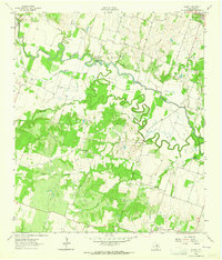 1963 Sharp1964 Print · USGSMilam County in the early sixties was a landscape of meandering river bends and small community anchors. Genealogists can trace family roots at Sharp Cem and McFarland Cem, or locate landmarks like the GC & SF rail line and Hall Sch.3 unique versions available
 - 1985 Map of Taylor, 1986 Print
 1985 Taylor1986 Print · USGSWilliamson and Bell counties in the mid-eighties reveal a landscape where the cattle and cotton economy met burgeoning rail infrastructure. Genealogists and historians can trace the paths of the Missouri Pacific railroad through unique hamlets like Ding Dong, Frame Switch, and Beyersville.2 unique versions available
End of results
Showing maps 1-5 of 5
Top cities near Cummins Crossing
- Temple historical maps
- Taylor historical maps
- Rockdale historical maps
- Cameron historical maps
- Little River-Academy historical maps
- Thorndale historical maps
See more
Frequently asked questions
- What are the different types of historical maps available for Cummins Crossing?
- What is the oldest map of Cummins Crossing?
- Where can I purchase historical maps of Cummins Crossing for my home or office?
- Where can I download high-res historical maps of Cummins Crossing?
- Are there historical topographic maps available for Cummins Crossing?
- Is there historical aerial imagery available for Cummins Crossing?
- Where are historical maps of Cummins Crossing sourced from?