Old Maps of Milam County, Texas for Genealogy
Trace your family roots with 201 historic maps of Milam County. These high-res maps reveal old neighborhoods, homesites, landmarks, and streets — helping you uncover where your ancestors lived and how the area evolved over time.
- Explore historic neighborhoods: Identify where your relatives may have lived in the 1800s or 1900s.
- Compare maps over time: Trace the changes in streets, buildings, and landmarks for multi-generational research.
- Perfect for genealogy & ancestry research: Used by family historians and researchers to map out lineage and migration.
These maps are an incredible resource for exploring your personal connection to Milam County's past.
Milam County, TX maps
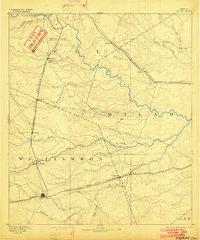
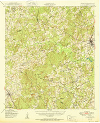
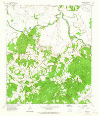
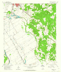
(201)- 1885 Map of Taylor
 1885 Taylor1885 Print · USGSCentral Texas in the late nineteenth century was a landscape in transition as railroads redefined the old cotton frontier. Genealogists and historians can trace the early growth of rail towns like Taylor and Granger, or find vanished rural outposts such as Ad Hall and Davilla.
 - 1885 Map of Bastrop
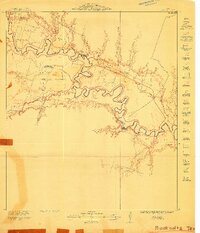
 1885 Bastrop1885 Print · USGSCentral Texas was undergoing a rail-driven transformation in the late nineteenth century as steam power connected the frontier to the Gulf. Genealogists can trace family names and old homesites near Rice's Crossing, Hills Prairie, and along the vital Houston and Texas Central Railroad.
 - 1887 Map of Taylor
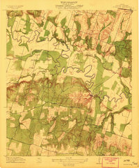
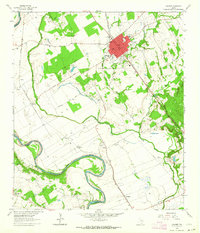
 1887 Taylor1887 Print · USGSCentral Texas is captured in the late nineteenth century as the railroad began to redefine the blackland prairie. Genealogists can locate early settlements like Davilla and Granger or trace family lands near the San Gabriel River and Taylor.
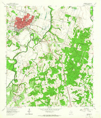
 - 1892 Map of Temple
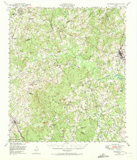
 1892 Temple1892 Print · USGSTexas at the turn of the century shows a landscape defined by emerging railroad junctions and river settlements. Genealogists can trace early homesteads and rail-town growth in Temple, McGregor, and Belton near the banks of the Leon River.6 unique versions available
 - 1893 Map of Bastrop
 1893 Bastrop1893 Print · USGSBastrop and the Colorado River valley are captured here in the late nineteenth century as the railroad transformed the Texas interior. Researchers can trace early property lines and community centers like Lexington, McDade, and the high vistas of the Yegua Knobs.
 - 1894 Map of Taylor, 1902 Print
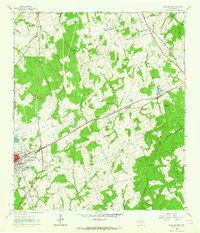
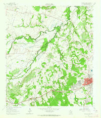
 1894 Taylor1902 Print · USGSCentral Texas at the end of the nineteenth century was a landscape of expanding rail lines and established river settlements. Genealogists and historians can trace the growth of Taylor and Granger, or locate smaller junctions like Ad Hall and Buckholts along the Gulf Colorado and Santa Fe Railroad.4 unique versions available
 - 1904 Map of Bastrop
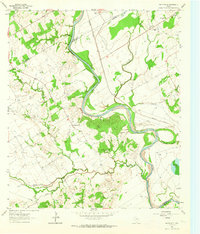
 1904 Bastrop1904 Print · USGSBastrop and Smithville thrive along the Colorado River at the turn of the century, serving as vital hubs for the Texas interior. Trace ancestral roots and old transport routes through Nashs Ferry, the Coal Mine near Sayersville, and Colorado Chapel.3 unique versions available
 - 1910 Map of Buckholts, 1911 Print
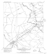
 1910 Buckholts1911 Print · USGSThe Milam County bottomlands along the Little River appear here just before major levee projects reshaped the valley. Trace family homesteads and crossings like the Live Oak School, Bryant Station Bridge, and Nielson Farm.
 - 1912 Map of Buckholts
 1912 Buckholts1912 Print · USGSMilam County was a landscape of river-bottom farms and rural school districts in the years before the Great War. You can trace early family holdings like Stink Hill Farm and find community landmarks such as Friendship Church and the Wire Bridge.
 - 1948 Map of Lexington, 1974 Print
 1948 Lexington1974 Print · USGSCentral Texas rural life in the late 1940s is captured here, showing the intersection of Lee, Milam, and Williamson counties. Genealogists can locate family burial sites at New Knobs Springs Cem and trace the influence of the Southern Pacific line through Lexington.
 - 1950 Map of Lexington
 1950 Lexington1950 Print · USGSLee and Bastrop Counties are captured in the late 1940s as rural crossroads like Beaukiss and Fedor thrived alongside the Southern Pacific railroad. Genealogists can trace family roots at New Knobs Springs Cem, Biehle Sch, and the Peat Mine.
 - 1954 Map of Waco, 1964 Print
 1954 Waco1964 Print · USGSCentral Texas during the mid-fifties shows a landscape defined by the expansion of Fort Hood Military Reservation and the Brazos river system. Trace the rail lines and early airfields like James Connally Air Force Base and settlements like Temple or McGregor.2 unique versions available
 - 1954 Map of Austin, 1964 Print
 1954 Austin1964 Print · USGSCentral Texas is captured during a period of steady growth as the capital city and its neighboring farm towns began to modernize. Researchers can trace historic rail corridors like the Southern Pacific RR or locate landmarks such as Bergstrom Air Force Base and Pilot Knob.4 unique versions available
 - 1955 Map of Waco
 1955 Waco1955 Print · USGSCentral Texas at the peak of the Cold War reveals a landscape defined by military expansion and major water projects. Researchers can trace the footprints of Fort Hood, the waters of Lake Waco, and regional hubs like Temple or Mexia.
 - 1956 Map of Caldwell
 1956 Caldwell1956 Print · USGSThe Brazos Valley at the end of the Great War era shows a landscape defined by cotton gins and river crossings. Trace family roots and vanished landmarks like Moseley's Ferry, Stone City, and the Skrabonek Gin near Caldwell.
 - 1956 Map of Milano
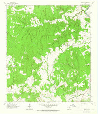
 1956 Milano1956 Print · USGSRailroad junctions and rural post offices define this Milam County landscape during the early twentieth century. Genealogists and historians can locate family-named landmarks like Septimus) Olson or trace the early paths of the San Antonio and Aransas Pass Railway.
 - 1961 Map of Mumford, 1964 Print
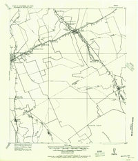
 1961 Mumford1964 Print · USGSThe Brazos River valley in the early sixties is a landscape of rural junctions and historic outposts at the meeting point of four counties. Researchers can locate the Fort Tenoxtitlan (Site), the rail sidings at Mudville, and local landmarks like Smith Sch.3 unique versions available
 - 1961 Map of Hanover, 1964 Print
 1961 Hanover1964 Print · USGSMilam County during the early sixties reveals a landscape of winding river bottoms and upland rural communities. Researchers can trace family history through sites like Oksheer-Smith Cem, the settlement of Hanover, and the White Oak Ridge Ch.2 unique versions available
 - 1961 Map of Cameron, 1964 Print
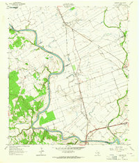
 1961 Cameron1964 Print · USGSMilam County centers on the rail-and-river economy of the early sixties, where the Gulf Colorado and Santa Fe meets the winding Little River. Genealogists and local historians can trace family-named sites like Burnham-McCowen Cem or the rural settlement at Hoyte.3 unique versions available
 - 1961 Map of Rockdale East, 1964 Print
 1961 Rockdale East1964 Print · USGSThe eastern edge of Rockdale and the surrounding Milam County prairie are captured in the early sixties, showing a landscape defined by rail lines and rural community centers. Family historians can trace local landmarks like Aycock Sch, San Jose Cem, and Mt Zion Ch.3 unique versions available
 - 1961 Map of Baileyville, 1964 Print
 1961 Baileyville1964 Print · USGSIn the early sixties, this rural intersection of Milam, Falls, and Robertson Counties was defined by its winding river bottomlands and family farmsteads. Researchers can locate family landmarks like Bozeman Cem, Morning Star Ch, and the Hooper Ranch.2 unique versions available
 - 1961 Map of Hearne South, 1964 Print
 1961 Hearne South1964 Print · USGSRailroad operations in the Brazos Valley defined the early 1960s landscape near the Milam and Robertson County line. Genealogists and local historians can trace the footprint of rural communities through sites like Tatsie Crossing, St Luke Cem, and the Blackshear High Sch.3 unique versions available
 - 1962 Map of Goodwill, 1963 Print
 1962 Goodwill1963 Print · USGSThe rural borderlands of Burleson and Milam counties are captured here in the early 1960s, centered on the community of Hix. Genealogists and local historians can trace the foundations of this area through St Mathews Ch, the Hix Cem, and family-named hollows like Bailey Hollow.2 unique versions available
 - 1962 Map of Calvert, 1964 Print
 1962 Calvert1964 Print · USGSCentral Robertson County's agricultural and rail heart is captured here in the early sixties. Researchers can trace family roots through the Calvert Cem, identify local schools like Spikes High Sch, and locate rural settlements near Marvin and Barton.3 unique versions available
 - 1962 Map of Rockdale West, 1964 Print
 1962 Rockdale West1964 Print · USGSMilam County in the early sixties shows the growth of Rockdale alongside traditional Texas river-bottom farming. Genealogists and historians can trace family locations through numerous sites like Hickory Grove Cem, Bushdale Cem, and Tracy.3 unique versions available
Showing maps 1-25 of 201
Top cities of Milam County
- Rockdale historical maps
- Cameron historical maps
- Thorndale historical maps
- Buckholts historical maps
- Milano historical maps
Frequently asked questions
- What are the different types of historical maps available for Milam County?
- What is the oldest map of Milam County?
- Where can I purchase historical maps of Milam County for my home or office?
- Where can I download high-res historical maps of Milam County?
- Are there historical topographic maps available for Milam County?
- Is there historical aerial imagery available for Milam County?
- Where are historical maps of Milam County sourced from?