1960s Maps of Mitchell County, Texas
Explore 7 historic maps of Mitchell County from the 1960s. These maps offer a rare glimpse into what life looked like during the 1960s — showing old roads, neighborhoods, homes, and landmarks that have changed or disappeared over time.
Whether you're researching your family's past, planning a metal detecting trip, or studying how Mitchell County's landscape evolved across the 1960s, these high-resolution maps are a powerful tool for exploring the history of this region.
- Focus on a specific era: All maps on this page are from the 1960s, giving you a focused view of this time period.
- See what’s changed: Compare century-old streets, trails, and buildings to today's modern landscape using overlays and satellite layers.
- Research with precision: Use these maps for genealogy, historical research, land use analysis, or educational projects.
- View, download, or print: Maps are fully viewable online in high resolution, and can be downloaded or printed for your own records.
Start exploring Mitchell County's history through authentic maps from the 1960s. This is your window into the past.
Mitchell County, TX maps
(7)- 1962 Map of Hyman NE, 1964 Print
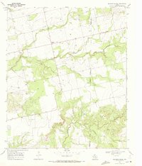
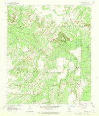 1962 Hyman NE1964 Print · USGSMitchell County ranchlands are captured here in the early sixties, showing the vital water and transit network of West Texas. Researchers can find working landmarks like Spring Sta, family-named water features like Vowell Tank, and the winding path of Beals Creek.2 unique versions available
 - 1963 Map of Buffalo Draw, 1964 Print
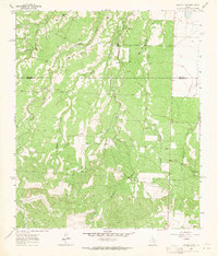 1963 Buffalo Draw1964 Print · USGSThe West Texas rangeland along the Mitchell and Sterling County line is captured here in the early sixties, showing a landscape defined by deep draws and cattle ranching. Trace early landmarks like Knobhill Cem and seasonal water sources like Hyman Tank and Mustang Creek.
 - 1963 Map of Hayrick Mountain, 1964 Print
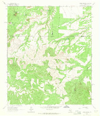 1963 Hayrick Mountain1964 Print · USGSWest Texas ranching and energy interests intersect at the turn of the sixties where Howard, Mitchell, and Sterling Counties meet. Trace the lineage of local landmarks like Dipping Vat Tank, Rockwater Hole, and Patsy Windmill.
 - 1963 Map of Hyman, 1965 Print
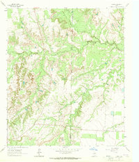 1963 Hyman1965 Print · USGSThe West Texas ranchlands and oil patches are captured here in the early 1960s as petroleum development expanded across the county line. Researchers can trace the infrastructure of the Hyman South Oil Field and locate family-named landmarks like Arrington Tank and Hamrick Tank.
 - 1969 Map of Baumann School, 1972 Print
 1969 Baumann School1972 Print · USGSMitchell and Nolan County ranch lands are captured here in the late sixties, showing a landscape defined by seasonal creek beds and rural infrastructure. Researchers can locate the Baumann School, trace the path of a major PIPELINE, and follow the winding South Fork Champion Creek.2 unique versions available
 - 1969 Map of Loraine, 1972 Print
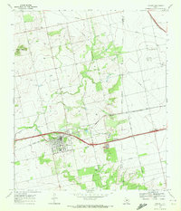 1969 Loraine1972 Print · USGSMitchell County ranching and rail infrastructure are captured here in the late sixties as the Texas and Pacific railroad serves the community of Loraine. Researchers can trace rural lineages at Union Chapel Cem and find landmarks like Lone Wolf Mountain or the Drive-in Theater.
 - 1969 Map of Inadale, 1973 Print
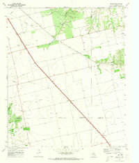 1969 Inadale1973 Print · USGSWest Texas rail junctions and agricultural boundaries are captured here in the late sixties as the region's economy relied on heavy rail transport. Trace the routes of the Roscoe Snyder and Pacific and locate family burial sites at Pyron Cem or Lone Wolf Cem.
End of results
Showing maps 1-7 of 7
Top cities of Mitchell County
Frequently asked questions
- What are the different types of historical maps available for Mitchell County?
- What is the oldest map of Mitchell County?
- Where can I purchase historical maps of Mitchell County for my home or office?
- Where can I download high-res historical maps of Mitchell County?
- Are there historical topographic maps available for Mitchell County?
- Is there historical aerial imagery available for Mitchell County?
- Where are historical maps of Mitchell County sourced from?