1940s Maps of Nacogdoches County, Texas
Explore 5 historic maps of Nacogdoches County from the 1940s. These maps offer a rare glimpse into what life looked like during the 1940s — showing old roads, neighborhoods, homes, and landmarks that have changed or disappeared over time.
Whether you're researching your family's past, planning a metal detecting trip, or studying how Nacogdoches County's landscape evolved across the 1940s, these high-resolution maps are a powerful tool for exploring the history of this region.
- Focus on a specific era: All maps on this page are from the 1940s, giving you a focused view of this time period.
- See what’s changed: Compare century-old streets, trails, and buildings to today's modern landscape using overlays and satellite layers.
- Research with precision: Use these maps for genealogy, historical research, land use analysis, or educational projects.
- View, download, or print: Maps are fully viewable online in high resolution, and can be downloaded or printed for your own records.
Start exploring Nacogdoches County's history through authentic maps from the 1940s. This is your window into the past.
Nacogdoches County, TX maps
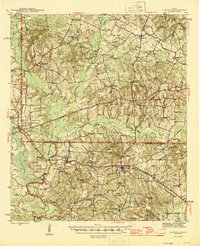
(5)- 1943 Map of Cushing, 1955 Print
 1943 Cushing1955 Print · USGSCushing and the rural crossroads of East Texas are seen here during the mid-forties as the railroad still anchored the local economy. Researchers can locate vanished rural landmarks like Freekeytown or trace the Southern Pacific line through Sacul and Reklaw.
 - 1945 Map of Cushing
 1945 Cushing1945 Print · USGSEast Texas farm and timber country thrives during the mid-forties along the borders of Nacogdoches, Rusk, and Cherokee counties. Genealogists can trace family roots through numerous rural landmarks like Mays Cem, Happy Valley Ch, and Glenwood Sch.
 - 1949 Map of Lufkin, 1961 Print
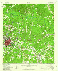 1949 Lufkin1961 Print · USGSPost-war Angelina County shows a growing Lufkin amid a landscape of timber and rail. Genealogists can trace family names through dozens of landmarks like Homer Cem, Jacob Chapel Cem, and the old settlement at Marion.2 unique versions available
 - 1949 Map of Platt, 1966 Print
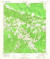
 1949 Platt1966 Print · USGSThe Angelina River bottomlands and pine forests of East Texas are captured here at mid-century, following the boundaries of Nacogdoches and Angelina counties. Researchers can locate the Site of Marian, trace the Southern Pacific rail line, and find family-named landmarks like Jacob Chapel Cem and Saints Rest Ch.3 unique versions available
 - 1949 Map of Clawson, 1966 Print
 1949 Clawson1966 Print · USGSDeep in East Texas at the end of the 1940s, this area shows a landscape defined by timber, the railroad, and the Angelina River. Genealogists can trace early homesteads and community hubs like Pollok, Clawson, and the Pollok Cem.3 unique versions available
End of results
Showing maps 1-5 of 5
Top cities of Nacogdoches County
- Nacogdoches historical maps
- Garrison historical maps
- Cushing historical maps
- Appleby historical maps
- Chireno historical maps
Frequently asked questions
- What are the different types of historical maps available for Nacogdoches County?
- What is the oldest map of Nacogdoches County?
- Where can I purchase historical maps of Nacogdoches County for my home or office?
- Where can I download high-res historical maps of Nacogdoches County?
- Are there historical topographic maps available for Nacogdoches County?
- Is there historical aerial imagery available for Nacogdoches County?
- Where are historical maps of Nacogdoches County sourced from?