1980s Maps of Parmer County, Texas
Explore 6 historic maps of Parmer County from the 1980s. These maps offer a rare glimpse into what life looked like during the 1980s — showing old roads, neighborhoods, homes, and landmarks that have changed or disappeared over time.
Whether you're researching your family's past, planning a metal detecting trip, or studying how Parmer County's landscape evolved across the 1980s, these high-resolution maps are a powerful tool for exploring the history of this region.
- Focus on a specific era: All maps on this page are from the 1980s, giving you a focused view of this time period.
- See what’s changed: Compare century-old streets, trails, and buildings to today's modern landscape using overlays and satellite layers.
- Research with precision: Use these maps for genealogy, historical research, land use analysis, or educational projects.
- View, download, or print: Maps are fully viewable online in high resolution, and can be downloaded or printed for your own records.
Start exploring Parmer County's history through authentic maps from the 1980s. This is your window into the past.
Parmer County, TX maps
(6)- 1985 Map of Pleasure Lake
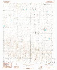
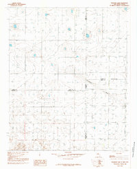 1985 Pleasure Lake1985 Print · USGSThe High Plains borderlands of New Mexico and Texas are captured here during the 1980s, showing a landscape of ranching and water management. Researchers can trace the interstate boundary and find localized landmarks like Pleasure Lake, a small Cem, and a large Feed Lot.
 - 1985 Map of Muleshoe
 1985 Muleshoe1985 Print · USGSThe High Plains of the Texas Panhandle in the mid-eighties show a landscape defined by industrial agriculture and rail. Genealogists and local historians can trace family roots through rural communities like Lazbuddie, Sudan, and the uniquely named town of Earth.2 unique versions available
 - 1985 Map of Pleasant Hill
 1985 Pleasant Hill1985 Print · USGSThe high plains borderland comes alive in the 1980s, centered on the settlement of Pleasant Hill. Researchers can trace the intersection of New Mexico and Texas across the drainages of Mustang Draw and Catfish Draw.
 - 1985 Map of Farwell
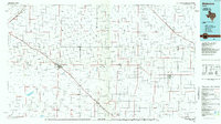
 1985 Farwell1985 Print · USGSThe border towns of Texico and Farwell straddle the state line in the mid-1980s, serving as an agricultural and transport hub. Researchers can trace the local economy and infrastructure through features like the Clovis Municipal Airport, the town Cem, and a large central Elevator.
 - 1985 Map of Pleasant Hill NE
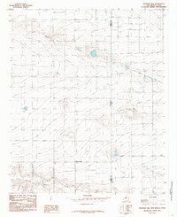
 1985 Pleasant Hill NE1985 Print · USGSThe High Plains borderlands of New Mexico and Texas come into focus during the mid-eighties, revealing a landscape of agricultural expansion. Genealogists and historians can trace the exact placement of early wells and landmarks like Frio Draw and the Radio Tower.
 - 1985 Map of Hereford
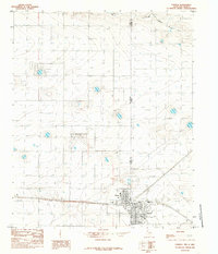
 1985 Hereford1985 Print · USGSThe High Plains of the Texas Panhandle are captured here during the mid-eighties, a period defined by vast agricultural grids and critical rail corridors. Genealogists and local historians can trace the footprint of settlements like Hereford, Dimmitt, and Bovina, alongside the Buffalo Lake National Wildlife Refuge.2 unique versions available
End of results
Showing maps 1-6 of 6
Top cities of Parmer County
Frequently asked questions
- What are the different types of historical maps available for Parmer County?
- What is the oldest map of Parmer County?
- Where can I purchase historical maps of Parmer County for my home or office?
- Where can I download high-res historical maps of Parmer County?
- Are there historical topographic maps available for Parmer County?
- Is there historical aerial imagery available for Parmer County?
- Where are historical maps of Parmer County sourced from?