
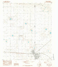
1985 Map of Pleasure Lake
USGS Topo · Published 1985About this map
Pleasure Lake sits at the heart of this High Plains borderland, where the Llano Estacado landscape is defined by thousands of small depressions and seasonal water features. The map documents a sparsely populated ranching and agricultural region just as it appeared in the mid-1980s, revealing the extensive infrastructure required for water management and livestock. Large-scale ranching operations are anchored by the Feed Lot and multiple clusters of Storage Bins, while the ephemeral Blackwater Draw cuts across the southeastern portion of the quadrangle. This survey is particularly valuable for its precise depiction of the interstate boundary between New Mexico and Texas, alongside complex county lines where Curry, Roosevelt, Parmer, and Bailey counties converge at the state line.
Find a feature on this map
11 named features on this map. Tap any name to fly to it.
Don’t see what you’re looking for? This feature index may not catch every label — zoom into the map to look around manually.
Map Details
Editions of this 1985 Pleasure Lake Map
This is the sole edition of this map. No revisions or reprints were ever made.
Other maps of this area

1954 · Clovis
USGS Topo · 1:250,000

1957 · Clovis
USGS Topo · 1:62,500

1957 · Arch
USGS Topo · 1:62,500

1958 · Clovis
USGS Topo · 1:250,000

1962 · Birdwell Ranch
USGS Topo · 1:24,000

1963 · Lariat
USGS Topo · 1:24,000

1963 · Oklahoma Lane
USGS Topo · 1:24,000

1985 · Midway
USGS Topo · 1:24,000

1985 · Muleshoe
USGS Topo · 1:100,000
1985 · Farwell
USGS Topo · 1:24,000