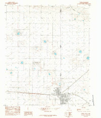
1985 Map of Farwell
USGS Topo · Published 1985About this map
The state line between New Mexico and Texas serves as the focal point for this 1980s-era survey, where the border towns of Texico and Farwell sit side-by-side. This twin-city arrangement highlights the regional significance of the high plains transport and agriculture hub, marked by a prominent Elevator and Radio Tower in the center of the settlements. The landscape is characterized by the expansive basin of Running Water Draw cutting across the northern half of the map, a key drainage feature in an otherwise flat expanse punctuated by Numerous wells and irrigation patterns.
Find a feature on this map
10 named features on this map. Tap any name to fly to it.
Don’t see what you’re looking for? This feature index may not catch every label — zoom into the map to look around manually.
Map Details
Editions of this 1985 Farwell Map
This is the sole edition of this map. No revisions or reprints were ever made.
Other maps of this area

1954 · Clovis
USGS Topo · 1:250,000

1957 · Clovis
USGS Topo · 1:62,500

1957 · Pleasant Hill
USGS Topo · 1:62,500

1958 · Clovis
USGS Topo · 1:250,000

1963 · Lariat
USGS Topo · 1:24,000

1963 · Oklahoma Lane
USGS Topo · 1:24,000

1965 · Bovina
USGS Topo · 1:24,000

1985 · Midway
USGS Topo · 1:24,000

1985 · Pleasure Lake
USGS Topo · 1:24,000

1985 · Muleshoe
USGS Topo · 1:100,000