1960s Maps of Clarksville, Texas
Explore 2 historic maps of Clarksville from the 1960s. These maps offer a rare glimpse into what life looked like during the 1960s — showing old roads, neighborhoods, homes, and landmarks that have changed or disappeared over time.
Whether you're researching your family's past, planning a metal detecting trip, or studying how Clarksville's landscape evolved across the 1960s, these high-resolution maps are a powerful tool for exploring the history of this region.
- Focus on a specific era: All maps on this page are from the 1960s, giving you a focused view of this time period.
- See what’s changed: Compare century-old streets, trails, and buildings to today's modern landscape using overlays and satellite layers.
- Research with precision: Use these maps for genealogy, historical research, land use analysis, or educational projects.
- View, download, or print: Maps are fully viewable online in high resolution, and can be downloaded or printed for your own records.
Start exploring Clarksville's history through authentic maps from the 1960s. This is your window into the past.
Clarksville, TX maps
(2)- 1964 Map of Dimple, 1967 Print
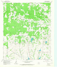 1964 Dimple1967 Print · USGSRed River County in the mid-sixties shows a landscape of creek-side settlements and managed water. Genealogists can locate family landmarks like Whitemans Chapel Cemetery, State Rock Church, and the rural community of Dimple.
 - 1964 Map of Clarksville, 1968 Print
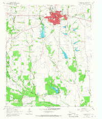 1964 Clarksville1968 Print · USGSRed River County centers on the busy hub of Clarksville in the mid-1960s, showing a landscape defined by the railroad and rural school districts. Genealogists and researchers can trace family landmarks like McKenzie Cemetery, the McKenzie College Historical Monument, and the route of the Texas and Pacific railroad.
End of results
Showing maps 1-2 of 2
Top cities near Clarksville
Frequently asked questions
- What are the different types of historical maps available for Clarksville?
- What is the oldest map of Clarksville?
- Where can I purchase historical maps of Clarksville for my home or office?
- Where can I download high-res historical maps of Clarksville?
- Are there historical topographic maps available for Clarksville?
- Is there historical aerial imagery available for Clarksville?
- Where are historical maps of Clarksville sourced from?