1980s Maps of Balmorhea, Texas
Explore 2 historic maps of Balmorhea from the 1980s. These maps offer a rare glimpse into what life looked like during the 1980s — showing old roads, neighborhoods, homes, and landmarks that have changed or disappeared over time.
Whether you're researching your family's past, planning a metal detecting trip, or studying how Balmorhea's landscape evolved across the 1980s, these high-resolution maps are a powerful tool for exploring the history of this region.
- Focus on a specific era: All maps on this page are from the 1980s, giving you a focused view of this time period.
- See what’s changed: Compare century-old streets, trails, and buildings to today's modern landscape using overlays and satellite layers.
- Research with precision: Use these maps for genealogy, historical research, land use analysis, or educational projects.
- View, download, or print: Maps are fully viewable online in high resolution, and can be downloaded or printed for your own records.
Start exploring Balmorhea's history through authentic maps from the 1980s. This is your window into the past.
Balmorhea, TX maps
(2)- 1980 Map of Balmorhea
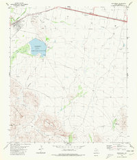 1980 Balmorhea1980 Print · USGSIn the Trans-Pecos desert during the early 1980s, Balmorhea and Brogado relied on a sophisticated network of canals and reservoirs. Genealogists and historians can trace the irrigation systems around Balmorhea Lake and locate the local Cem and Athletic Field.
 - 1985 Map of Fort Davis, 1994 Print
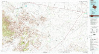 1985 Fort Davis1994 Print · USGSWest Texas in the mid-eighties shows a landscape of high desert peaks and vital spring-fed irrigation. Trace the development of Toyahvale and Balmorhea, or locate specific landmarks like the Fort Davis National Historic Site and Robbers Roost.2 unique versions available
End of results
Showing maps 1-2 of 2
Frequently asked questions
- What are the different types of historical maps available for Balmorhea?
- What is the oldest map of Balmorhea?
- Where can I purchase historical maps of Balmorhea for my home or office?
- Where can I download high-res historical maps of Balmorhea?
- Are there historical topographic maps available for Balmorhea?
- Is there historical aerial imagery available for Balmorhea?
- Where are historical maps of Balmorhea sourced from?