1970s Maps of Reklaw, Texas
Explore 4 historic maps of Reklaw from the 1970s. These maps offer a rare glimpse into what life looked like during the 1970s — showing old roads, neighborhoods, homes, and landmarks that have changed or disappeared over time.
Whether you're researching your family's past, planning a metal detecting trip, or studying how Reklaw's landscape evolved across the 1970s, these high-resolution maps are a powerful tool for exploring the history of this region.
- Focus on a specific era: All maps on this page are from the 1970s, giving you a focused view of this time period.
- See what’s changed: Compare century-old streets, trails, and buildings to today's modern landscape using overlays and satellite layers.
- Research with precision: Use these maps for genealogy, historical research, land use analysis, or educational projects.
- View, download, or print: Maps are fully viewable online in high resolution, and can be downloaded or printed for your own records.
Start exploring Reklaw's history through authentic maps from the 1970s. This is your window into the past.
Reklaw, TX maps
(4)- 1973 Map of New Summerfield, 1976 Print
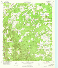
 1973 New Summerfield1976 Print · USGSCherokee County in the early seventies reveals a landscape of timbered hills and quiet railroad sidings. Genealogists can trace family connections at Union Hill Cem and Walkers Chapel Cem or locate the historic rail junctions at Ponta and Stryker Creek Junction.
 - 1973 Map of Atoy, 1976 Print
 1973 Atoy1976 Print · USGSEast Texas rural life in the 1970s centers on timbered hills and quiet settlements like Atoy and Circle. Genealogists and historians can trace family locations through Walker Cem and Cornelius Cem, or locate landmarks like Jim Hogg State Park.
 - 1973 Map of New Salem, 1976 Print
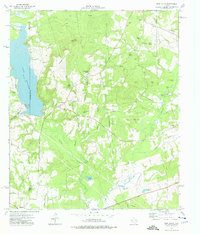 1973 New Salem1976 Print · USGSThe border of Rusk and Cherokee counties in the early 1970s shows a landscape of East Texas timber and industry. Trace the legacy of rural communities at New Salem and Anadarko, alongside historic sites like Cool Springs Cem and the Southern Pacific railroad.
 - 1973 Map of Reklaw, 1976 Print
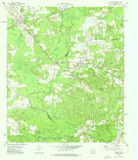 1973 Reklaw1976 Print · USGSThe rural tri-county borderlands of East Texas are captured here in the 1970s, as the Southern Pacific rail line linked small timber and farming outposts. Genealogists can locate family landmarks like Looney Cem and McKnight Ch, or trace the old paths near Dextra.
End of results
Showing maps 1-4 of 4
Top cities near Reklaw
- Jacksonville historical maps
- Rusk historical maps
- Alto historical maps
- New Summerfield historical maps
- Cushing historical maps
- Gallatin historical maps
Frequently asked questions
- What are the different types of historical maps available for Reklaw?
- What is the oldest map of Reklaw?
- Where can I purchase historical maps of Reklaw for my home or office?
- Where can I download high-res historical maps of Reklaw?
- Are there historical topographic maps available for Reklaw?
- Is there historical aerial imagery available for Reklaw?
- Where are historical maps of Reklaw sourced from?