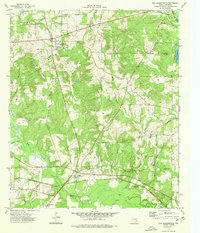
1973 Map of New Summerfield
USGS Topo · Published 1976About this map
New Summerfield sits at the intersection of a landscape defined by East Texas timber and transit in the early 1970s. The area is marked by a dense concentration of family and community burial grounds, including the Union Chapel Cem, Myrtle Springs Cem, and Plainview Cem, suggesting deep genealogical roots in this portion of Cherokee County. The eastern edge of the survey is dominated by Lake Striker Elevation 293, while the Southern Pacific railroad cuts through the southern reaches, connecting the settlements of Ponta and Stryker Creek Junction.
Find a feature on this map
44 named features on this map. Tap any name to fly to it.
Don’t see what you’re looking for? This feature index may not catch every label — zoom into the map to look around manually.
Map Details
Editions of this 1973 New Summerfield Map
This is the sole edition of this map. No revisions or reprints were ever made.
Other maps of this area

1935 · Henderson
USGS Topo · 1:48,000

1937 · Troupe
USGS Topo · 1:48,000

1939 · Henderson
USGS Topo · 1:62,500

1943 · Troup
USGS Topo · 1:62,500

1943 · Cushing
USGS Topo · 1:62,500

1943 · Rusk
USGS Topo · 1:62,500

1945 · Cushing
USGS Topo · 1:62,500

1945 · Rusk
USGS Topo · 1:62,500

1953 · Palestine
USGS Topo · 1:250,000

1956 · Tyler
USGS Topo · 1:250,000